Piggs Peak geodata
Piggs Peak (Hhohho) is a seat of a first-order administrative division; located in Eswatini in Africa/Mbabane (GMT+2) time zone. With population of 5,750 people, there are 8 cities with bigger population in this country. Compared to other cities in Eswatini, 95.5% of cities are located further ↓South; 63.6% of cities are located further →East and 72.7% of cities have lower elevation than Piggs Peak. Note1


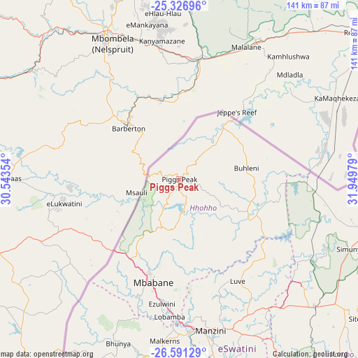
Piggs Peak GPS coordinates[2]
25° 57' 38.952" South, 31° 14' 47.976" East
| Map corner | latitude | longitude |
|---|---|---|
| Upper-left | -25.32696°, | 30.54354° |
| Center: | -25.96082°, | 31.24666° |
| Lower-right: | -26.59129°, | 31.94979° |
| Map W x H: | 140.6×140.6 km | = 87.4×87.4mi |
| max Lat: | -25.82659° ⇑4.5% North |
| Piggs Peak: | -25.96082° |
| min Lat: | ⇓95.5% South -27.31005° |
| min Long | Piggs Peak | max Long |
| 31.01667° | 31.24666° | 31.95° |
| W 36.4%⇐ | ⇒63.6% E |
Elevation
Elevation of Piggs Peak is 1018 m = 3340 ft, and this is 339.5 m = 1114 ft above average elevation for this country.
| Max E: |
1317 m = 4321 ft | 27.3% |
| Piggs Peak | 1018 m 3340 ft | |
| Avg. | 678.5 m = 2226 ft | |
Min E: |
109 m = 358 ft | 72.7% |
See also: Eswatini elevation on elevation.city.
Geographical zone
Piggs Peak is located in South temperate zone (between Tropic of Capricorn and the Antarctic Circle). Distance of this Southern Tropic circle is 280.7 km =174.4 mi to North.| Distance of | km | miles | from Piggs Peak |
|---|---|---|---|
| Equator | 2886.6 | 1793.6 | to North |
| Tropic Capricorn | 280.7 | 174.4 | to North |
| Antarctic Circle | 4514.6 | 2805.2 | to South |
| South Pole | 7120.5 | 4424.5 | to South |


Nearby cities:
15 places around Piggs Peak: (largest is in red/bold)
• Bhunya
69.4 km =43.1 mi,  199°
199°
• Bulembu
11.3 km =7 mi,  266°
266°
• Darkton
37 km =23 mi,  215°
215°
• Kwaluseni
58.7 km =36.5 mi,  171°
171°
• Lobamba
56.4 km =35 mi,  184°
184°
• Malkerns
67.7 km =42.1 mi,  185°
185°
• Manzini
61.3 km =38.1 mi, 167°
• Mbabane
41.2 km =25.6 mi, 195°
• Mhlambanyatsi
59 km =36.7 mi, 202°
• Mhlume
60.8 km =37.8 mi,  97°
97°
• Ntfonjeni
17 km =10.6 mi,  28°
28°
• Sidvokodvo
76.2 km =47.3 mi, 166°
• Siteki
88.7 km =55.1 mi,  128°
128°
• Tshaneni
47 km =29.2 mi,  93°
93°
• Vuvulane
64.2 km =39.9 mi, 101°
Sources, notices
• [Note1] Compared only with cities in Eswatini existing in our database
• [Src1] Map data: © OpenStreetMap contributors (CC-BY-SA)
• [Src2] Other city data from geonames.org with taken over terms of usage.
• [Src3] Geographical zone / Annual Mean Temperature by Robert A. Rohde @ Wikipedia
