Vuvulane geodata
Vuvulane (Lubombo) is a populated place; located in Eswatini in Africa/Mbabane (GMT+2) time zone. With population of 4,155 people, there are 10 cities with bigger population in this country. Compared to other cities in Eswatini, 77.3% of cities are located further ↓South; 81.8% of cities are located further ←West and 81.8% of cities have higher elevation than Vuvulane. Note1


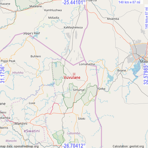
Vuvulane GPS coordinates[2]
26° 4' 27.372" South, 31° 52' 36.192" East
| Map corner | latitude | longitude |
|---|---|---|
| Upper-left | -25.44101°, | 31.1736° |
| Center: | -26.07427°, | 31.87672° |
| Lower-right: | -26.70412°, | 32.57985° |
| Map W x H: | 140.4×140.4 km | = 87.2×87.2mi |
| max Lat: | -25.82659° ⇑22.7% North |
| Vuvulane: | -26.07427° |
| min Lat: | ⇓77.3% South -27.31005° |
| min Long | Vuvulane | max Long |
| 31.01667° | 31.87672° | 31.95° |
| W 81.8%⇐ | ⇒18.2% E |
Elevation
Elevation of Vuvulane is 273 m = 896 ft, and this is 405.5 m = 1330 ft below average elevation for this country.
| Max E: |
1317 m = 4321 ft | 81.8% |
| Avg. | 678.5 m = 2226 ft | |
| Vuvulane | 273 m = 896 ft | |
Min E: |
109 m = 358 ft | 18.2% |
See also: Eswatini elevation on elevation.city.
Geographical zone
Vuvulane is located in South temperate zone (between Tropic of Capricorn and the Antarctic Circle). Distance of this Southern Tropic circle is 293.3 km =182.2 mi to North.| Distance of | km | miles | from Vuvulane |
|---|---|---|---|
| Equator | 2899.2 | 1801.5 | to North |
| Tropic Capricorn | 293.3 | 182.2 | to North |
| Antarctic Circle | 4502 | 2797.4 | to South |
| South Pole | 7107.9 | 4416.6 | to South |


Nearby cities:
15 places around Vuvulane: (largest is in red/bold)
• Big Bend
82.7 km =51.4 mi,  176°
176°
• Bulembu
75.2 km =46.7 mi,  279°
279°
• Darkton
86 km =53.4 mi,  258°
258°
• Kwaluseni
70.7 km =43.9 mi,  229°
229°
• Lobamba
80.4 km =50 mi,  237°
237°
• Malkerns
88.2 km =54.8 mi, 231°
• Manzini
68.4 km =42.5 mi, 226°
• Mbabane
78.9 km =49 mi,  250°
250°
• Mhlambanyatsi
95.4 km =59.3 mi, 244°
• Mhlume
5.3 km =3.3 mi,  329°
329°
• Ntfonjeni
61.4 km =38.2 mi,  296°
296°
• Piggs Peak
64.2 km =39.9 mi, 281°
• Sidvokodvo
76.6 km =47.6 mi,  216°
216°
• Siteki
42.6 km =26.5 mi,  170°
170°
• Tshaneni
18.9 km =11.7 mi, 302°
Sources, notices
• [Note1] Compared only with cities in Eswatini existing in our database
• [Src1] Map data: © OpenStreetMap contributors (CC-BY-SA)
• [Src2] Other city data from geonames.org with taken over terms of usage.
• [Src3] Geographical zone / Annual Mean Temperature by Robert A. Rohde @ Wikipedia
