Bulembu geodata
Bulembu (Hhohho) is a populated place; located in Eswatini in Africa/Mbabane (GMT+2) time zone. With population of 2,260 people, there are 15 cities with bigger population in this country. Compared to other cities in Eswatini, 90.9% of cities are located further ↓South; 86.4% of cities are located further →East and 81.8% of cities have lower elevation than Bulembu. Note1


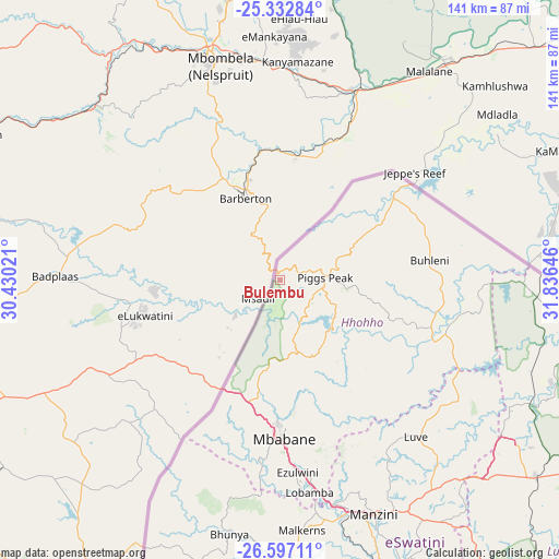
Bulembu GPS coordinates[2]
25° 58' 0.012" South, 31° 7' 59.988" East
| Map corner | latitude | longitude |
|---|---|---|
| Upper-left | -25.33284°, | 30.43021° |
| Center: | -25.96667°, | 31.13333° |
| Lower-right: | -26.59711°, | 31.83646° |
| Map W x H: | 140.6×140.6 km | = 87.4×87.4mi |
| max Lat: | -25.82659° ⇑9.1% North |
| Bulembu: | -25.96667° |
| min Lat: | ⇓90.9% South -27.31005° |
| min Long | Bulembu | max Long |
| 31.01667° | 31.13333° | 31.95° |
| W 13.6%⇐ | ⇒86.4% E |
Elevation
Elevation of Bulembu is 1078 m = 3537 ft, and this is 399.5 m = 1311 ft above average elevation for this country.
| Max E: |
1317 m = 4321 ft | 18.2% |
| Bulembu | 1078 m 3537 ft | |
| Avg. | 678.5 m = 2226 ft | |
Min E: |
109 m = 358 ft | 81.8% |
See also: Eswatini elevation on elevation.city.
Geographical zone
Bulembu is located in South temperate zone (between Tropic of Capricorn and the Antarctic Circle). Distance of this Southern Tropic circle is 281.3 km =174.8 mi to North.| Distance of | km | miles | from Bulembu |
|---|---|---|---|
| Equator | 2887.2 | 1794 | to North |
| Tropic Capricorn | 281.3 | 174.8 | to North |
| Antarctic Circle | 4514 | 2804.9 | to South |
| South Pole | 7119.8 | 4424 | to South |


Nearby cities:
15 places around Bulembu: (largest is in red/bold)
• Bhunya
65.9 km =40.9 mi,  190°
190°
• Darkton
31.3 km =19.4 mi,  198°
198°
• Kwaluseni
60.8 km =37.8 mi,  160°
160°
• Lobamba
56 km =34.8 mi,  173°
173°
• Malkerns
66.9 km =41.6 mi,  175°
175°
• Manzini
64.1 km =39.8 mi, 157°
• Mbabane
38.9 km =24.2 mi, 180°
• Mhlambanyatsi
55 km =34.2 mi, 192°
• Mhlume
72 km =44.7 mi,  95°
95°
• Ntfonjeni
24.9 km =15.5 mi,  51°
51°
• Piggs Peak
11.3 km =7 mi,  86°
86°
• Sidvokodvo
78.9 km =49 mi, 158°
• Siteki
97.5 km =60.6 mi,  123°
123°
• Tshaneni
58.3 km =36.2 mi, 91°
• Vuvulane
75.2 km =46.7 mi, 99°
Sources, notices
• [Note1] Compared only with cities in Eswatini existing in our database
• [Src1] Map data: © OpenStreetMap contributors (CC-BY-SA)
• [Src2] Other city data from geonames.org with taken over terms of usage.
• [Src3] Geographical zone / Annual Mean Temperature by Robert A. Rohde @ Wikipedia
