Bokoro geodata
Bokoro (Hadjer-Lamis) is a populated place; located in Chad in Africa/Ndjamena (GMT+1) time zone. With population of 14,723 people, there are 24 cities with bigger population in this country. Compared to other cities in Chad, 61.7% of cities are located further ↓South; 53.2% of cities are located further ←West and 85.1% of cities have higher elevation than Bokoro. Note1


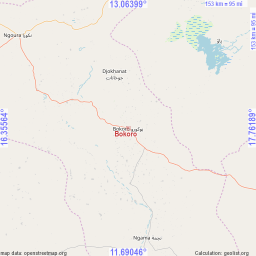
Bokoro GPS coordinates[2]
12° 22' 41.268" North, 17° 3' 31.536" East
| Map corner | latitude | longitude |
|---|---|---|
| Upper-left | 13.06399°, | 16.35564° |
| Center: | 12.37813°, | 17.05876° |
| Lower-right: | 11.69046°, | 17.76189° |
| Map W x H: | 152.7×152.7 km | = 94.9×94.9mi |
| max Lat: | 21.8375° ⇑38.3% North |
| Bokoro: | 12.37813° |
| min Lat: | ⇓61.7% South 8.26681° |
| min Long | Bokoro | max Long |
| 14.1539° | 17.05876° | 22.84308° |
| W 53.2%⇐ | ⇒46.8% E |
Elevation
Elevation of Bokoro is 300 m = 984 ft, and this is 137.3 m = 450 ft below average elevation for this country.
| Max E: |
1046 m = 3432 ft | 85.1% |
| Avg. | 437.3 m = 1435 ft | |
| Bokoro | 300 m = 984 ft | |
Min E: |
242 m = 794 ft | 14.9% |
See also: Chad elevation on elevation.city.
Geographical zone
Bokoro is located in North Torrid zone (between Equator and Tropic of Cancer). Distance of this Northern Tropic circle is 1229.6 km =764 mi to North.| Distance of | km | miles | from Bokoro |
|---|---|---|---|
| North Pole | 8630.7 | 5362.9 | to North |
| Arctic Circle | 6024.9 | 3743.7 | to North |
| Tropic Cancer | 1229.6 | 764 | to North |
| Equator | 1376.3 | 855.2 | to South |


Nearby cities:
15 places around Bokoro: (largest is in red/bold)
• Ati
166.8 km =103.6 mi,  56°
56°
• Bitkine
133.1 km =82.7 mi,  109°
109°
• Bol
281.5 km =174.9 mi,  295°
295°
• Bousso
213.9 km =132.9 mi,  190°
190°
• Dourbali
144.3 km =89.7 mi,  243°
243°
• Guelendeng
231 km =143.5 mi,  225°
225°
• Mao
270.9 km =168.3 mi,  315°
315°
• Massaguet
176.5 km =109.7 mi,  273°
273°
• Massakory
159.7 km =99.2 mi, 295°
• Massenya
145.2 km =90.2 mi,  221°
221°
• Melfi
174.9 km =108.7 mi,  146°
146°
• Mongo
178.9 km =111.2 mi,  96°
96°
• Moussoro
153.4 km =95.3 mi,  336°
336°
• N'Djamena
221 km =137.3 mi,  262°
262°
• Ngama
67.2 km =41.8 mi,  169°
169°
Sources, notices
• [Note1] Compared only with cities in Chad existing in our database
• [Src1] Map data: © OpenStreetMap contributors (CC-BY-SA)
• [Src2] Other city data from geonames.org with taken over terms of usage.
• [Src3] Geographical zone / Annual Mean Temperature by Robert A. Rohde @ Wikipedia
