Varzob geodata
Varzob (Republican Subordination) is a populated place; located in Tajikistan in Asia/Dushanbe (GMT+5) time zone. With population of 2,154 people, there are 61 cities with bigger population in this country. Compared to other cities in Tajikistan, 59.1% of cities are located further ↓South; 71.6% of cities are located further →East and 63.6% of cities have lower elevation than Varzob. Note1


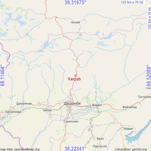
Varzob GPS coordinates[2]
38° 46' 25.284" North, 68° 49' 3.936" East
| Map corner | latitude | longitude |
|---|---|---|
| Upper-left | 39.31975°, | 68.11464° |
| Center: | 38.77369°, | 68.81776° |
| Lower-right: | 38.22341°, | 69.52089° |
| Map W x H: | 121.9×121.9 km | = 75.7×75.7mi |
| max Lat: | 40.99827° ⇑40.9% North |
| Varzob: | 38.77369° |
| min Lat: | ⇓59.1% South 36.72484° |
| min Long | Varzob | max Long |
| 67.60931° | 68.81776° | 73.96674° |
| W 28.4%⇐ | ⇒71.6% E |
Elevation
Elevation of Varzob is 1107 m = 3632 ft, and this is 144.5 m = 474 ft above average elevation for this country.
| Max E: |
3607 m = 11834 ft | 36.4% |
| Varzob | 1107 m 3632 ft | |
| Avg. | 962.5 m = 3158 ft | |
Min E: |
324 m = 1063 ft | 63.6% |
See also: Tajikistan elevation on elevation.city.
Geographical zone
Varzob is located in North temperate zone (between Tropic of Cancer and the Arctic Circle). Distance of this Northern Tropic circle is 1705.3 km =1059.6 mi to South.| Distance of | km | miles | from Varzob |
|---|---|---|---|
| North Pole | 5695.8 | 3539.2 | to North |
| Arctic Circle | 3089.9 | 1920 | to North |
| Tropic Cancer | 1705.3 | 1059.6 | to South |
| Equator | 4311.2 | 2678.9 | to South |


Nearby cities:
15 places around Varzob: (largest is in red/bold)
• Ayní
73.1 km =45.4 mi,  340°
340°
• Boshkengash
34.2 km =21.3 mi,  181°
181°
• Dushanbe
26.7 km =16.6 mi,  187°
187°
• Fayzobod
50.3 km =31.3 mi,  120°
120°
• Hisor
36.1 km =22.4 mi,  219°
219°
• Khodzha-Maston
16.9 km =10.5 mi,  258°
258°
• Norak
61.3 km =38.1 mi,  134°
134°
• Obigarm
77.5 km =48.2 mi,  94°
94°
• Obikiik
69.5 km =43.2 mi, 190°
• Shahrinav
47.6 km =29.6 mi,  241°
241°
• Somoniyon
37.1 km =23.1 mi, 185°
• Tagob
10 km =6.2 mi,  44°
44°
• Tursunzoda
58.6 km =36.4 mi, 240°
• Vahdat
29.5 km =18.3 mi,  144°
144°
• Yovon
54.6 km =33.9 mi,  159°
159°
Sources, notices
• [Note1] Compared only with cities in Tajikistan existing in our database
• [Src1] Map data: © OpenStreetMap contributors (CC-BY-SA)
• [Src2] Other city data from geonames.org with taken over terms of usage.
• [Src3] Geographical zone / Annual Mean Temperature by Robert A. Rohde @ Wikipedia
