Vanj geodata
Vanj (Gorno-Badakhshan) is a seat of a second-order administrative division; located in Tajikistan in Asia/Dushanbe (GMT+5) time zone. In our database, there are 65 cities with bigger population. Compared to other cities in Tajikistan, 58% of cities are located further ↑North; 93.2% of cities are located further ←West and 89.8% of cities have lower elevation than Vanj. Note1


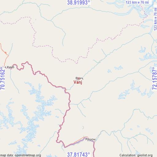
Vanj GPS coordinates[2]
38° 22' 14.808" North, 71° 27' 17.064" East
| Map corner | latitude | longitude |
|---|---|---|
| Upper-left | 38.91993°, | 70.75162° |
| Center: | 38.37078°, | 71.45474° |
| Lower-right: | 37.81743°, | 72.15787° |
| Map W x H: | 122.6×122.6 km | = 76.2×76.2mi |
| max Lat: | 40.99827° ⇑58% North |
| Vanj: | 38.37078° |
| min Lat: | ⇓42% South 36.72484° |
| min Long | Vanj | max Long |
| 67.60931° | 71.45474° | 73.96674° |
| W 93.2%⇐ | ⇒6.8% E |
Elevation
Elevation of Vanj is 1779 m = 5837 ft, and this is 816.5 m = 2679 ft above average elevation for this country.
| Max E: |
3607 m = 11834 ft | 10.2% |
| Vanj | 1779 m 5837 ft | |
| Avg. | 962.5 m = 3158 ft | |
Min E: |
324 m = 1063 ft | 89.8% |
See also: Tajikistan elevation on elevation.city.
Geographical zone
Vanj is located in North temperate zone (between Tropic of Cancer and the Arctic Circle). Distance of this Northern Tropic circle is 1660.5 km =1031.8 mi to South.| Distance of | km | miles | from Vanj |
|---|---|---|---|
| North Pole | 5740.6 | 3567 | to North |
| Arctic Circle | 3134.7 | 1947.8 | to North |
| Tropic Cancer | 1660.5 | 1031.8 | to South |
| Equator | 4266.4 | 2651 | to South |


Nearby cities:
15 places around Vanj: (largest is in red/bold)
• Darband
140.6 km =87.4 mi,  293°
293°
• Jirghatol
97.1 km =60.3 mi,  346°
346°
• Karakenja
96.4 km =59.9 mi,  3°
3°
• Khorugh
98.3 km =61.1 mi,  174°
174°
• Khovaling
129 km =80.2 mi,  268°
268°
• Mŭ’minobod
127.6 km =79.3 mi,  256°
256°
• Novobod
133.7 km =83.1 mi,  302°
302°
• Qalaikhumb
58.7 km =36.5 mi,  279°
279°
• Rasht
118.9 km =73.9 mi,  307°
307°
• Roghun
145.1 km =90.2 mi, 288°
• Roshtqal’a
127.9 km =79.5 mi, 165°
• Rŭshon
48.2 km =30 mi, 169°
• Shŭrobod
136.4 km =84.8 mi,  244°
244°
• Tajikobod
99.3 km =61.7 mi,  327°
327°
• Tavildara
91.8 km =57 mi, 293°
Sources, notices
• [Note1] Compared only with cities in Tajikistan existing in our database
• [Src1] Map data: © OpenStreetMap contributors (CC-BY-SA)
• [Src2] Other city data from geonames.org with taken over terms of usage.
• [Src3] Geographical zone / Annual Mean Temperature by Robert A. Rohde @ Wikipedia
