Roshtqal’a geodata
Roshtqal’a (Gorno-Badakhshan) is a seat of a second-order administrative division; located in Tajikistan in Asia/Dushanbe (GMT+5) time zone. In our database, there are 65 cities with bigger population. Compared to other cities in Tajikistan, 97.7% of cities are located further ↑North; 98.9% of cities are located further ←West and 98.9% of cities have lower elevation than Roshtqal’a. Note1


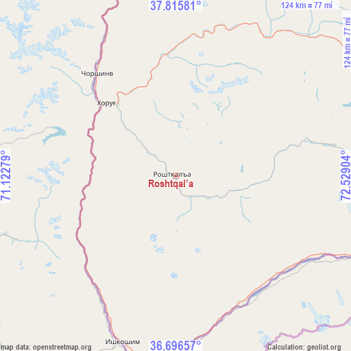
Roshtqal’a GPS coordinates[2]
37° 15' 29.772" North, 71° 49' 33.276" East
| Map corner | latitude | longitude |
|---|---|---|
| Upper-left | 37.81581°, | 71.12279° |
| Center: | 37.25827°, | 71.82591° |
| Lower-right: | 36.69657°, | 72.52904° |
| Map W x H: | 124.4×124.4 km | = 77.3×77.3mi |
| max Lat: | 40.99827° ⇑97.7% North |
| Roshtqal’a: | 37.25827° |
| min Lat: | ⇓2.3% South 36.72484° |
| min Long | Roshtqal’a | max Long |
| 67.60931° | 71.82591° | 73.96674° |
| W 98.9%⇐ | ⇒1.1% E |
Elevation
Elevation of Roshtqal’a is 2696 m = 8845 ft, and this is 1733.5 m = 5687 ft above average elevation for this country.
| Max E: |
3607 m = 11834 ft | 1.1% |
| Roshtqal’a | 2696 m 8845 ft | |
| Avg. | 962.5 m = 3158 ft | |
Min E: |
324 m = 1063 ft | 98.9% |
See also: Tajikistan elevation on elevation.city.
Geographical zone
Roshtqal’a is located in North temperate zone (between Tropic of Cancer and the Arctic Circle). Distance of this Northern Tropic circle is 1536.8 km =954.9 mi to South.| Distance of | km | miles | from Roshtqal’a |
|---|---|---|---|
| North Pole | 5864.3 | 3643.9 | to North |
| Arctic Circle | 3258.4 | 2024.7 | to North |
| Tropic Cancer | 1536.8 | 954.9 | to South |
| Equator | 4142.7 | 2574.2 | to South |


Nearby cities:
15 places around Roshtqal’a: (largest is in red/bold)
• Chubek
191.4 km =118.9 mi,  281°
281°
• Farkhor
215.6 km =134 mi, 276°
• Ishqoshim
62.2 km =38.6 mi,  197°
197°
• Khorugh
35.3 km =21.9 mi,  316°
316°
• Khovaling
202.4 km =125.8 mi,  306°
306°
• Kŭlob
194.1 km =120.6 mi,  292°
292°
• Moskva
199 km =123.7 mi, 283°
• Murghob
213.9 km =132.9 mi,  61°
61°
• Mŭ’minobod
183.9 km =114.3 mi,  300°
300°
• Qalaikhumb
161.1 km =100.1 mi,  325°
325°
• Rŭshon
79.9 km =49.6 mi,  342°
342°
• Shŭrobod
169.6 km =105.4 mi, 292°
• Tavildara
198.4 km =123.3 mi, 323°
• Vanj
127.9 km =79.5 mi,  345°
345°
• Vose’
201.7 km =125.3 mi, 287°
Sources, notices
• [Note1] Compared only with cities in Tajikistan existing in our database
• [Src1] Map data: © OpenStreetMap contributors (CC-BY-SA)
• [Src2] Other city data from geonames.org with taken over terms of usage.
• [Src3] Geographical zone / Annual Mean Temperature by Robert A. Rohde @ Wikipedia
