Khorugh geodata
Khorugh (Gorno-Badakhshan) is a seat of a first-order administrative division; located in Tajikistan in Asia/Dushanbe (GMT+5) time zone. With population of 30,000 people, there are 10 cities with bigger population in this country. Compared to other cities in Tajikistan, 92% of cities are located further ↑North; 95.5% of cities are located further ←West and 95.5% of cities have lower elevation than Khorugh. Note1


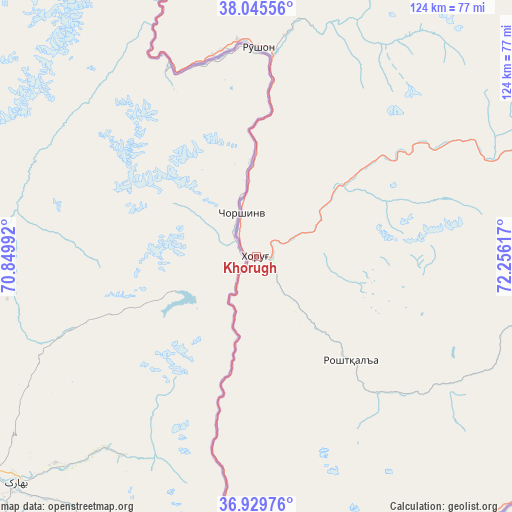
Khorugh GPS coordinates[2]
37° 29' 23.064" North, 71° 33' 10.944" East
| Map corner | latitude | longitude |
|---|---|---|
| Upper-left | 38.04556°, | 70.84992° |
| Center: | 37.48974°, | 71.55304° |
| Lower-right: | 36.92976°, | 72.25617° |
| Map W x H: | 124.1×124.1 km | = 77.1×77.1mi |
| max Lat: | 40.99827° ⇑92% North |
| Khorugh: | 37.48974° |
| min Lat: | ⇓8% South 36.72484° |
| min Long | Khorugh | max Long |
| 67.60931° | 71.55304° | 73.96674° |
| W 95.5%⇐ | ⇒4.5% E |
Elevation
Elevation of Khorugh is 2089 m = 6854 ft, and this is 1126.5 m = 3696 ft above average elevation for this country.
| Max E: |
3607 m = 11834 ft | 4.5% |
| Khorugh | 2089 m 6854 ft | |
| Avg. | 962.5 m = 3158 ft | |
Min E: |
324 m = 1063 ft | 95.5% |
See also: Tajikistan elevation on elevation.city.
Geographical zone
Khorugh is located in North temperate zone (between Tropic of Cancer and the Arctic Circle). Distance of this Northern Tropic circle is 1562.5 km =970.9 mi to South.| Distance of | km | miles | from Khorugh |
|---|---|---|---|
| North Pole | 5838.6 | 3627.9 | to North |
| Arctic Circle | 3232.7 | 2008.7 | to North |
| Tropic Cancer | 1562.5 | 970.9 | to South |
| Equator | 4168.5 | 2590.2 | to South |


Nearby cities:
15 places around Khorugh: (largest is in red/bold)
• Baljuvon
188.1 km =116.9 mi,  298°
298°
• Chubek
163.5 km =101.6 mi,  274°
274°
• Ishqoshim
85.2 km =52.9 mi,  176°
176°
• Khovaling
167.7 km =104.2 mi, 304°
• Kŭlob
162.6 km =101 mi,  286°
286°
• Moskva
170.7 km =106.1 mi,  276°
276°
• Mŭ’minobod
150.2 km =93.3 mi, 297°
• Qalaikhumb
126.4 km =78.5 mi,  328°
328°
• Roshtqal’a
35.3 km =21.9 mi,  136°
136°
• Rŭshon
50.6 km =31.4 mi,  0°
0°
• Shŭrobod
138.1 km =85.8 mi, 286°
• Sovet
183.5 km =114 mi, 289°
• Tavildara
163.4 km =101.5 mi, 325°
• Vanj
98.3 km =61.1 mi,  354°
354°
• Vose’
171.6 km =106.6 mi, 281°
Sources, notices
• [Note1] Compared only with cities in Tajikistan existing in our database
• [Src1] Map data: © OpenStreetMap contributors (CC-BY-SA)
• [Src2] Other city data from geonames.org with taken over terms of usage.
• [Src3] Geographical zone / Annual Mean Temperature by Robert A. Rohde @ Wikipedia
