Istaravshan geodata
Istaravshan (Sughd) is a seat of a second-order administrative division; located in Tajikistan in Asia/Dushanbe (GMT+5) time zone. With population of 52,851 people, there are 4 cities with bigger population in this country. Compared to other cities in Tajikistan, 75% of cities are located further ↓South; 62.5% of cities are located further →East and 61.4% of cities have lower elevation than Istaravshan. Note1


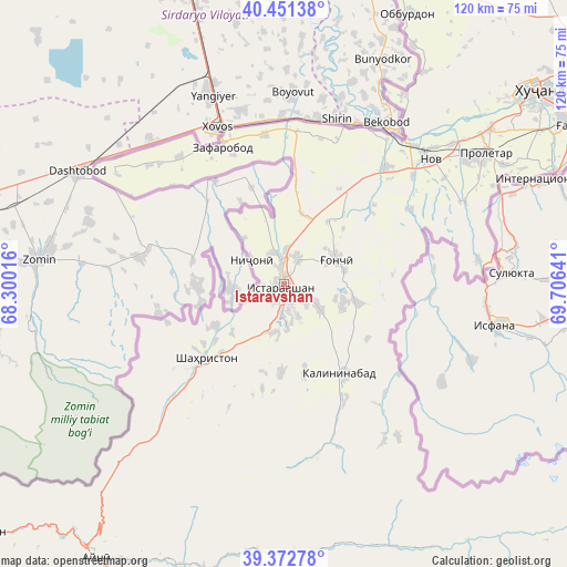
Istaravshan GPS coordinates[2]
39° 54' 51.12" North, 69° 0' 11.808" East
| Map corner | latitude | longitude |
|---|---|---|
| Upper-left | 40.45138°, | 68.30016° |
| Center: | 39.9142°, | 69.00328° |
| Lower-right: | 39.37278°, | 69.70641° |
| Map W x H: | 119.9×119.9 km | = 74.5×74.5mi |
| max Lat: | 40.99827° ⇑25% North |
| Istaravshan: | 39.9142° |
| min Lat: | ⇓75% South 36.72484° |
| min Long | Istaravshan | max Long |
| 67.60931° | 69.00328° | 73.96674° |
| W 37.5%⇐ | ⇒62.5% E |
Elevation
Elevation of Istaravshan is 979 m = 3212 ft, and this is 16.5 m = 54 ft above average elevation for this country.
| Max E: |
3607 m = 11834 ft | 38.6% |
| Istaravshan | 979 m 3212 ft | |
| Avg. | 962.5 m = 3158 ft | |
Min E: |
324 m = 1063 ft | 61.4% |
See also: Istaravshan elevation on elevation.city.
Geographical zone
Istaravshan is located in North temperate zone (between Tropic of Cancer and the Arctic Circle). Distance of this Northern Tropic circle is 1832.1 km =1138.4 mi to South.| Distance of | km | miles | from Istaravshan |
|---|---|---|---|
| North Pole | 5569 | 3460.4 | to North |
| Arctic Circle | 2963.1 | 1841.2 | to North |
| Tropic Cancer | 1832.1 | 1138.4 | to South |
| Equator | 4438 | 2757.6 | to South |


Nearby cities:
15 places around Istaravshan: (largest is in red/bold)
• Ayní
70.2 km =43.6 mi,  214°
214°
• Bŭston
73.2 km =45.5 mi,  22°
22°
• Chkalov
68.8 km =42.8 mi,  58°
58°
• Ghafurov
70.2 km =43.6 mi, 61°
• Ghonchí
12 km =7.5 mi, 63°
• Khŭjand
66.7 km =41.4 mi,  52°
52°
• Konsoy
87.4 km =54.3 mi,  42°
42°
• Mehron
60.4 km =37.5 mi,  156°
156°
• Nov
41 km =25.5 mi, 49°
• Pakhtakoron
34.7 km =21.6 mi,  321°
321°
• Palos
76.8 km =47.7 mi, 54°
• Proletar
50.9 km =31.6 mi, 56°
• Quruqsoy
80.3 km =49.9 mi, 23°
• Shahriston
22.7 km =14.1 mi,  226°
226°
• Zafarobod
32 km =19.9 mi,  335°
335°
In other languages:
- In France: Istaravchan
- In German: Istarawschan
- In Italian: Istaravšan
- In Russian: Истаравшан
- In Chinese: 伊斯塔拉夫尚
Sources, notices
• [Note1] Compared only with cities in Tajikistan existing in our database
• [Src1] Map data: © OpenStreetMap contributors (CC-BY-SA)
• [Src2] Other city data from geonames.org with taken over terms of usage.
• [Src3] Geographical zone / Annual Mean Temperature by Robert A. Rohde @ Wikipedia
