Bŭston geodata
Bŭston (Sughd) is a seat of a second-order administrative division; located in Tajikistan in Asia/Dushanbe (GMT+5) time zone. With population of 13,043 people, there are 27 cities with bigger population in this country. Compared to other cities in Tajikistan, 93.2% of cities are located further ↓South; 53.4% of cities are located further →East and 100% of cities have higher elevation than Bŭston. Note1


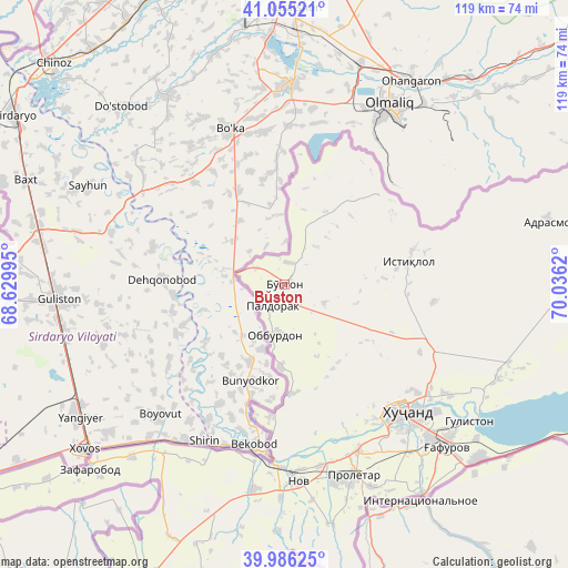
Bŭston GPS coordinates[2]
40° 31' 22.296" North, 69° 19' 59.052" East
| Map corner | latitude | longitude |
|---|---|---|
| Upper-left | 41.05521°, | 68.62995° |
| Center: | 40.52286°, | 69.33307° |
| Lower-right: | 39.98625°, | 70.0362° |
| Map W x H: | 118.9×118.9 km | = 73.9×73.9mi |
| max Lat: | 40.99827° ⇑6.8% North |
| Bŭston: | 40.52286° |
| min Lat: | ⇓93.2% South 36.72484° |
| min Long | Bŭston | max Long |
| 67.60931° | 69.33307° | 73.96674° |
| W 46.6%⇐ | ⇒53.4% E |
Elevation
Elevation of Bŭston is 324 m = 1063 ft, and this is 638.5 m = 2095 ft below average elevation for this country.
| Max E: |
3607 m = 11834 ft | 100% |
| Avg. | 962.5 m = 3158 ft | |
| Bŭston | 324 m = 1063 ft | |
Min E: |
324 m = 1063 ft | 0% |
See also: Tajikistan elevation on elevation.city.
Geographical zone
Bŭston is located in North temperate zone (between Tropic of Cancer and the Arctic Circle). Distance of this Northern Tropic circle is 1899.8 km =1180.5 mi to South.| Distance of | km | miles | from Bŭston |
|---|---|---|---|
| North Pole | 5501.3 | 3418.3 | to North |
| Arctic Circle | 2895.5 | 1799.2 | to North |
| Tropic Cancer | 1899.8 | 1180.5 | to South |
| Equator | 4505.7 | 2799.7 | to South |


Nearby cities:
15 places around Bŭston: (largest is in red/bold)
• Adrasmon
56.8 km =35.3 mi,  75°
75°
• Chkalov
44.4 km =27.6 mi,  136°
136°
• Ghafurov
47.8 km =29.7 mi, 135°
• Ghonchí
64.7 km =40.2 mi,  195°
195°
• Istaravshan
73.2 km =45.5 mi, 202°
• Khŭjand
36.2 km =22.5 mi, 137°
• Konsoy
31.4 km =19.5 mi,  96°
96°
• Nov
41.3 km =25.7 mi,  175°
175°
• Oltintopkan
26.7 km =16.6 mi,  56°
56°
• Pakhtakoron
64.2 km =39.9 mi,  230°
230°
• Palos
41.2 km =25.6 mi,  123°
123°
• Proletar
42.1 km =26.2 mi,  160°
160°
• Quruqsoy
7.1 km =4.4 mi,  33°
33°
• Taboshar
26.6 km =16.5 mi, 78°
• Zafarobod
56.4 km =35 mi, 226°
Sources, notices
• [Note1] Compared only with cities in Tajikistan existing in our database
• [Src1] Map data: © OpenStreetMap contributors (CC-BY-SA)
• [Src2] Other city data from geonames.org with taken over terms of usage.
• [Src3] Geographical zone / Annual Mean Temperature by Robert A. Rohde @ Wikipedia
