Chkalov geodata
Chkalov (Sughd) is a populated place; located in Tajikistan in Asia/Dushanbe (GMT+5) time zone. With population of 21,537 people, there are 18 cities with bigger population in this country. Compared to other cities in Tajikistan, 87.5% of cities are located further ↓South; 61.4% of cities are located further ←West and 80.7% of cities have higher elevation than Chkalov. Note1


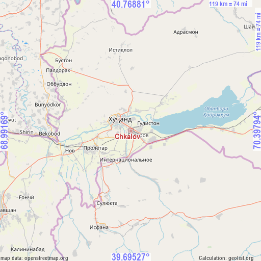
Chkalov GPS coordinates[2]
40° 14' 3.012" North, 69° 41' 41.316" East
| Map corner | latitude | longitude |
|---|---|---|
| Upper-left | 40.76881°, | 68.99169° |
| Center: | 40.23417°, | 69.69481° |
| Lower-right: | 39.69527°, | 70.39794° |
| Map W x H: | 119.4×119.4 km | = 74.2×74.2mi |
| max Lat: | 40.99827° ⇑12.5% North |
| Chkalov: | 40.23417° |
| min Lat: | ⇓87.5% South 36.72484° |
| min Long | Chkalov | max Long |
| 67.60931° | 69.69481° | 73.96674° |
| W 61.4%⇐ | ⇒38.6% E |
Elevation
Elevation of Chkalov is 415 m = 1362 ft, and this is 547.5 m = 1796 ft below average elevation for this country.
| Max E: |
3607 m = 11834 ft | 80.7% |
| Avg. | 962.5 m = 3158 ft | |
| Chkalov | 415 m = 1362 ft | |
Min E: |
324 m = 1063 ft | 19.3% |
See also: Tajikistan elevation on elevation.city.
Geographical zone
Chkalov is located in North temperate zone (between Tropic of Cancer and the Arctic Circle). Distance of this Northern Tropic circle is 1867.7 km =1160.5 mi to South.| Distance of | km | miles | from Chkalov |
|---|---|---|---|
| North Pole | 5533.4 | 3438.3 | to North |
| Arctic Circle | 2927.6 | 1819.1 | to North |
| Tropic Cancer | 1867.7 | 1160.5 | to South |
| Equator | 4473.6 | 2779.8 | to South |


Nearby cities:
15 places around Chkalov: (largest is in red/bold)
• Adrasmon
52.3 km =32.5 mi,  27°
27°
• Bŭston
44.4 km =27.6 mi,  316°
316°
• Ghafurov
3.5 km =2.2 mi,  125°
125°
• Ghonchí
56.8 km =35.3 mi,  237°
237°
• Istaravshan
68.8 km =42.8 mi, 238°
• Khŭjand
8.2 km =5.1 mi,  311°
311°
• Kim
65.8 km =40.9 mi,  92°
92°
• Konibodom
62.8 km =39 mi,  83°
83°
• Konsoy
28.6 km =17.8 mi,  1°
1°
• Nov
29 km =18 mi,  251°
251°
• Oltintopkan
47.4 km =29.5 mi,  350°
350°
• Palos
9.8 km =6.1 mi,  21°
21°
• Proletar
18 km =11.2 mi, 245°
• Quruqsoy
46.5 km =28.9 mi, 324°
• Taboshar
37.6 km =23.4 mi, 353°
Sources, notices
• [Note1] Compared only with cities in Tajikistan existing in our database
• [Src1] Map data: © OpenStreetMap contributors (CC-BY-SA)
• [Src2] Other city data from geonames.org with taken over terms of usage.
• [Src3] Geographical zone / Annual Mean Temperature by Robert A. Rohde @ Wikipedia
