Khŭjand geodata
Khŭjand (Sughd) is a seat of a first-order administrative division; located in Tajikistan in Asia/Dushanbe (GMT+5) time zone. With population of 144,865 people, there is 1 city with bigger population in this country. Compared to other cities in Tajikistan, 88.6% of cities are located further ↓South; 55.7% of cities are located further ←West and 98.9% of cities have higher elevation than Khŭjand. Note1


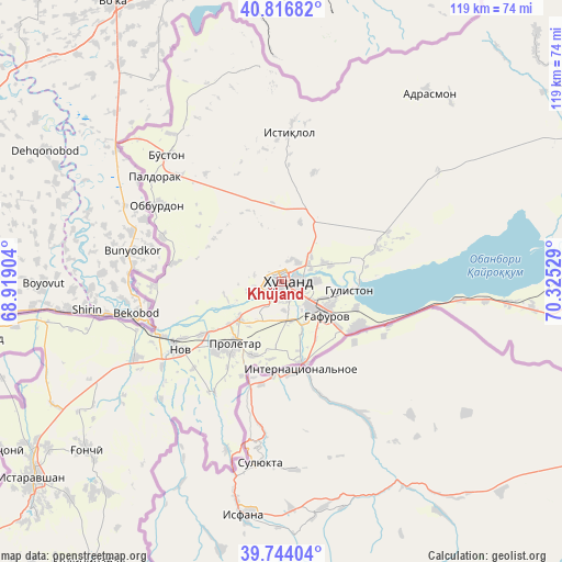
Khŭjand GPS coordinates[2]
40° 16' 57.216" North, 69° 37' 19.776" East
| Map corner | latitude | longitude |
|---|---|---|
| Upper-left | 40.81682°, | 68.91904° |
| Center: | 40.28256°, | 69.62216° |
| Lower-right: | 39.74404°, | 70.32529° |
| Map W x H: | 119.3×119.3 km | = 74.1×74.1mi |
| max Lat: | 40.99827° ⇑11.4% North |
| Khŭjand: | 40.28256° |
| min Lat: | ⇓88.6% South 36.72484° |
| min Long | Khŭjand | max Long |
| 67.60931° | 69.62216° | 73.96674° |
| W 55.7%⇐ | ⇒44.3% E |
Elevation
Elevation of Khŭjand is 340 m = 1115 ft, and this is 622.5 m = 2042 ft below average elevation for this country.
| Max E: |
3607 m = 11834 ft | 98.9% |
| Avg. | 962.5 m = 3158 ft | |
| Khŭjand | 340 m = 1115 ft | |
Min E: |
324 m = 1063 ft | 1.1% |
See also: Khŭjand elevation on elevation.city.
Geographical zone
Khŭjand is located in North temperate zone (between Tropic of Cancer and the Arctic Circle). Distance of this Northern Tropic circle is 1873.1 km =1163.9 mi to South.| Distance of | km | miles | from Khŭjand |
|---|---|---|---|
| North Pole | 5528.1 | 3435 | to North |
| Arctic Circle | 2922.2 | 1815.8 | to North |
| Tropic Cancer | 1873.1 | 1163.9 | to South |
| Equator | 4479 | 2783.1 | to South |


Nearby cities:
15 places around Khŭjand: (largest is in red/bold)
• Adrasmon
51 km =31.7 mi,  36°
36°
• Bŭston
36.2 km =22.5 mi,  317°
317°
• Chkalov
8.2 km =5.1 mi,  131°
131°
• Ghafurov
11.7 km =7.3 mi, 129°
• Ghonchí
55 km =34.2 mi,  229°
229°
• Istaravshan
66.7 km =41.4 mi, 232°
• Konibodom
68.6 km =42.6 mi,  88°
88°
• Konsoy
24.2 km =15 mi,  16°
16°
• Nov
25.8 km =16 mi,  235°
235°
• Oltintopkan
41.4 km =25.7 mi,  357°
357°
• Palos
10.5 km =6.5 mi,  69°
69°
• Proletar
16.4 km =10.2 mi,  218°
218°
• Quruqsoy
38.6 km =24 mi,  327°
327°
• Taboshar
32 km =19.9 mi,  2°
2°
• Zafarobod
66.9 km =41.6 mi,  259°
259°
In other languages:
- In Spanish: Khodjent
- In France: Khodjent
- In German: Chudschand
- In Russian: Худжанд
Sources, notices
• [Note1] Compared only with cities in Tajikistan existing in our database
• [Src1] Map data: © OpenStreetMap contributors (CC-BY-SA)
• [Src2] Other city data from geonames.org with taken over terms of usage.
• [Src3] Geographical zone / Annual Mean Temperature by Robert A. Rohde @ Wikipedia
