Quruqsoy geodata
Quruqsoy (Sughd) is a populated place; located in Tajikistan in Asia/Dushanbe (GMT+5) time zone. With population of 3,288 people, there are 55 cities with bigger population in this country. Compared to other cities in Tajikistan, 95.5% of cities are located further ↓South; 50% of cities are located further ←West and 71.6% of cities have higher elevation than Quruqsoy. Note1


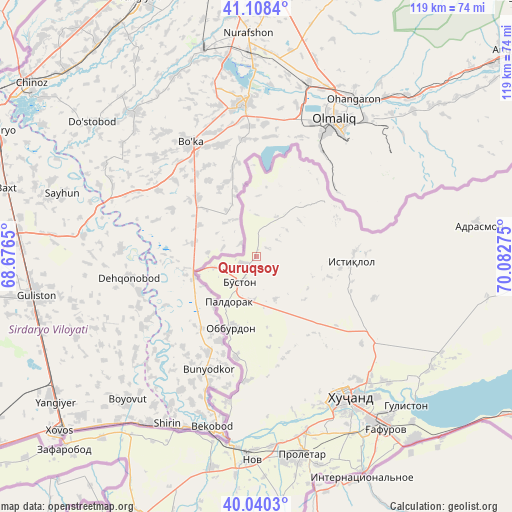
Quruqsoy GPS coordinates[2]
40° 34' 35.328" North, 69° 22' 46.632" East
| Map corner | latitude | longitude |
|---|---|---|
| Upper-left | 41.1084°, | 68.6765° |
| Center: | 40.57648°, | 69.37962° |
| Lower-right: | 40.0403°, | 70.08275° |
| Map W x H: | 118.8×118.8 km | = 73.8×73.8mi |
| max Lat: | 40.99827° ⇑4.5% North |
| Quruqsoy: | 40.57648° |
| min Lat: | ⇓95.5% South 36.72484° |
| min Long | Quruqsoy | max Long |
| 67.60931° | 69.37962° | 73.96674° |
| W 50%⇐ | ⇒50% E |
Elevation
Elevation of Quruqsoy is 433 m = 1421 ft, and this is 529.5 m = 1737 ft below average elevation for this country.
| Max E: |
3607 m = 11834 ft | 71.6% |
| Avg. | 962.5 m = 3158 ft | |
| Quruqsoy | 433 m = 1421 ft | |
Min E: |
324 m = 1063 ft | 28.4% |
See also: Tajikistan elevation on elevation.city.
Geographical zone
Quruqsoy is located in North temperate zone (between Tropic of Cancer and the Arctic Circle). Distance of this Northern Tropic circle is 1905.8 km =1184.2 mi to South.| Distance of | km | miles | from Quruqsoy |
|---|---|---|---|
| North Pole | 5495.4 | 3414.7 | to North |
| Arctic Circle | 2889.5 | 1795.5 | to North |
| Tropic Cancer | 1905.8 | 1184.2 | to South |
| Equator | 4511.7 | 2803.4 | to South |


Nearby cities:
15 places around Quruqsoy: (largest is in red/bold)
• Adrasmon
51.7 km =32.1 mi,  80°
80°
• Bŭston
7.1 km =4.4 mi,  213°
213°
• Chkalov
46.5 km =28.9 mi,  144°
144°
• Ghafurov
49.8 km =30.9 mi, 143°
• Ghonchí
71.5 km =44.4 mi,  197°
197°
• Istaravshan
80.3 km =49.9 mi, 203°
• Khŭjand
38.6 km =24 mi,  147°
147°
• Konsoy
28.9 km =18 mi,  109°
109°
• Nov
47.2 km =29.3 mi,  180°
180°
• Oltintopkan
20.4 km =12.7 mi,  64°
64°
• Pakhtakoron
71.1 km =44.2 mi,  228°
228°
• Palos
41.9 km =26 mi,  133°
133°
• Proletar
46.7 km =29 mi,  167°
167°
• Taboshar
22.1 km =13.7 mi,  91°
91°
• Zafarobod
63.4 km =39.4 mi, 225°
Sources, notices
• [Note1] Compared only with cities in Tajikistan existing in our database
• [Src1] Map data: © OpenStreetMap contributors (CC-BY-SA)
• [Src2] Other city data from geonames.org with taken over terms of usage.
• [Src3] Geographical zone / Annual Mean Temperature by Robert A. Rohde @ Wikipedia
