Proletar geodata
Proletar (Sughd) is a seat of a second-order administrative division; located in Tajikistan in Asia/Dushanbe (GMT+5) time zone. With population of 16,441 people, there are 23 cities with bigger population in this country. Compared to other cities in Tajikistan, 81.8% of cities are located further ↓South; 52.3% of cities are located further ←West and 90.9% of cities have higher elevation than Proletar. Note1


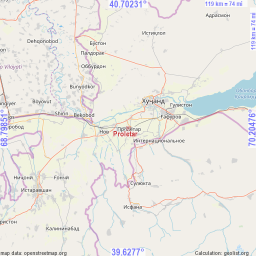
Proletar GPS coordinates[2]
40° 10' 1.668" North, 69° 30' 5.868" East
| Map corner | latitude | longitude |
|---|---|---|
| Upper-left | 40.70231°, | 68.79851° |
| Center: | 40.16713°, | 69.50163° |
| Lower-right: | 39.6277°, | 70.20476° |
| Map W x H: | 119.5×119.5 km | = 74.3×74.3mi |
| max Lat: | 40.99827° ⇑18.2% North |
| Proletar: | 40.16713° |
| min Lat: | ⇓81.8% South 36.72484° |
| min Long | Proletar | max Long |
| 67.60931° | 69.50163° | 73.96674° |
| W 52.3%⇐ | ⇒47.7% E |
Elevation
Elevation of Proletar is 382 m = 1253 ft, and this is 580.5 m = 1905 ft below average elevation for this country.
| Max E: |
3607 m = 11834 ft | 90.9% |
| Avg. | 962.5 m = 3158 ft | |
| Proletar | 382 m = 1253 ft | |
Min E: |
324 m = 1063 ft | 9.1% |
See also: Tajikistan elevation on elevation.city.
Geographical zone
Proletar is located in North temperate zone (between Tropic of Cancer and the Arctic Circle). Distance of this Northern Tropic circle is 1860.2 km =1155.9 mi to South.| Distance of | km | miles | from Proletar |
|---|---|---|---|
| North Pole | 5540.9 | 3443 | to North |
| Arctic Circle | 2935 | 1823.7 | to North |
| Tropic Cancer | 1860.2 | 1155.9 | to South |
| Equator | 4466.2 | 2775.2 | to South |


Nearby cities:
15 places around Proletar: (largest is in red/bold)
• Adrasmon
67.4 km =41.9 mi,  37°
37°
• Bŭston
42.1 km =26.2 mi,  340°
340°
• Chkalov
18 km =11.2 mi,  65°
65°
• Ghafurov
20 km =12.4 mi, 74°
• Ghonchí
39 km =24.2 mi,  234°
234°
• Istaravshan
50.9 km =31.6 mi,  236°
236°
• Khŭjand
16.4 km =10.2 mi, 38°
• Konsoy
39.9 km =24.8 mi,  25°
25°
• Nov
11.2 km =7 mi,  261°
261°
• Oltintopkan
54.8 km =34.1 mi,  8°
8°
• Pakhtakoron
64.2 km =39.9 mi,  269°
269°
• Palos
26 km =16.2 mi,  50°
50°
• Quruqsoy
46.7 km =29 mi,  347°
347°
• Taboshar
46.4 km =28.8 mi, 14°
• Zafarobod
55.6 km =34.5 mi, 271°
Sources, notices
• [Note1] Compared only with cities in Tajikistan existing in our database
• [Src1] Map data: © OpenStreetMap contributors (CC-BY-SA)
• [Src2] Other city data from geonames.org with taken over terms of usage.
• [Src3] Geographical zone / Annual Mean Temperature by Robert A. Rohde @ Wikipedia
