Ghafurov geodata
Ghafurov (Sughd) is a seat of a second-order administrative division; located in Tajikistan in Asia/Dushanbe (GMT+5) time zone. In our database, there are 65 cities with bigger population. Compared to other cities in Tajikistan, 86.4% of cities are located further ↓South; 65.9% of cities are located further ←West and 78.4% of cities have higher elevation than Ghafurov. Note1


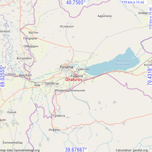
Ghafurov GPS coordinates[2]
40° 12' 56.556" North, 69° 43' 43.212" East
| Map corner | latitude | longitude |
|---|---|---|
| Upper-left | 40.7505°, | 69.02555° |
| Center: | 40.21571°, | 69.72867° |
| Lower-right: | 39.67667°, | 70.4318° |
| Map W x H: | 119.4×119.4 km | = 74.2×74.2mi |
| max Lat: | 40.99827° ⇑13.6% North |
| Ghafurov: | 40.21571° |
| min Lat: | ⇓86.4% South 36.72484° |
| min Long | Ghafurov | max Long |
| 67.60931° | 69.72867° | 73.96674° |
| W 65.9%⇐ | ⇒34.1% E |
Elevation
Elevation of Ghafurov is 422 m = 1385 ft, and this is 540.5 m = 1773 ft below average elevation for this country.
| Max E: |
3607 m = 11834 ft | 78.4% |
| Avg. | 962.5 m = 3158 ft | |
| Ghafurov | 422 m = 1385 ft | |
Min E: |
324 m = 1063 ft | 21.6% |
See also: Tajikistan elevation on elevation.city.
Geographical zone
Ghafurov is located in North temperate zone (between Tropic of Cancer and the Arctic Circle). Distance of this Northern Tropic circle is 1865.6 km =1159.2 mi to South.| Distance of | km | miles | from Ghafurov |
|---|---|---|---|
| North Pole | 5535.5 | 3439.6 | to North |
| Arctic Circle | 2929.6 | 1820.4 | to North |
| Tropic Cancer | 1865.6 | 1159.2 | to South |
| Equator | 4471.6 | 2778.5 | to South |


Nearby cities:
15 places around Ghafurov: (largest is in red/bold)
• Adrasmon
52.9 km =32.9 mi,  24°
24°
• Bŭston
47.8 km =29.7 mi,  315°
315°
• Chkalov
3.5 km =2.2 mi,  305°
305°
• Ghonchí
58.2 km =36.2 mi,  241°
241°
• Istaravshan
70.2 km =43.6 mi, 241°
• Khŭjand
11.7 km =7.3 mi, 309°
• Kim
62.9 km =39.1 mi,  90°
90°
• Konibodom
60.3 km =37.5 mi,  81°
81°
• Konsoy
30.8 km =19.1 mi,  355°
355°
• Nov
31.2 km =19.4 mi,  256°
256°
• Oltintopkan
50 km =31.1 mi,  347°
347°
• Palos
11.2 km =7 mi,  3°
3°
• Proletar
20 km =12.4 mi,  254°
254°
• Quruqsoy
49.8 km =30.9 mi, 323°
• Taboshar
40.1 km =24.9 mi, 349°
Sources, notices
• [Note1] Compared only with cities in Tajikistan existing in our database
• [Src1] Map data: © OpenStreetMap contributors (CC-BY-SA)
• [Src2] Other city data from geonames.org with taken over terms of usage.
• [Src3] Geographical zone / Annual Mean Temperature by Robert A. Rohde @ Wikipedia
