Zafarobod geodata
Zafarobod (Sughd) is a seat of a second-order administrative division; located in Tajikistan in Asia/Dushanbe (GMT+5) time zone. In our database, there are 65 cities with bigger population. Compared to other cities in Tajikistan, 83% of cities are located further ↓South; 67% of cities are located further →East and 83% of cities have higher elevation than Zafarobod. Note1


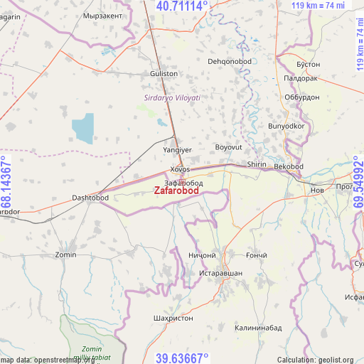
Zafarobod GPS coordinates[2]
40° 10' 33.708" North, 68° 50' 48.444" East
| Map corner | latitude | longitude |
|---|---|---|
| Upper-left | 40.71114°, | 68.14367° |
| Center: | 40.17603°, | 68.84679° |
| Lower-right: | 39.63667°, | 69.54992° |
| Map W x H: | 119.5×119.5 km | = 74.3×74.3mi |
| max Lat: | 40.99827° ⇑17% North |
| Zafarobod: | 40.17603° |
| min Lat: | ⇓83% South 36.72484° |
| min Long | Zafarobod | max Long |
| 67.60931° | 68.84679° | 73.96674° |
| W 33%⇐ | ⇒67% E |
Elevation
Elevation of Zafarobod is 405 m = 1329 ft, and this is 557.5 m = 1829 ft below average elevation for this country.
| Max E: |
3607 m = 11834 ft | 83% |
| Avg. | 962.5 m = 3158 ft | |
| Zafarobod | 405 m = 1329 ft | |
Min E: |
324 m = 1063 ft | 17% |
See also: Tajikistan elevation on elevation.city.
Geographical zone
Zafarobod is located in North temperate zone (between Tropic of Cancer and the Arctic Circle). Distance of this Northern Tropic circle is 1861.2 km =1156.5 mi to South.| Distance of | km | miles | from Zafarobod |
|---|---|---|---|
| North Pole | 5539.9 | 3442.3 | to North |
| Arctic Circle | 2934 | 1823.1 | to North |
| Tropic Cancer | 1861.2 | 1156.5 | to South |
| Equator | 4467.2 | 2775.8 | to South |


Nearby cities:
15 places around Zafarobod: (largest is in red/bold)
• Bŭston
56.4 km =35 mi,  46°
46°
• Chkalov
72.3 km =44.9 mi,  84°
84°
• Ghafurov
75 km =46.6 mi,  86°
86°
• Ghonchí
33.8 km =21 mi,  134°
134°
• Istaravshan
32 km =19.9 mi,  155°
155°
• Khŭjand
66.9 km =41.6 mi, 79°
• Konsoy
80.6 km =50.1 mi,  64°
64°
• Nov
44.6 km =27.7 mi, 93°
• Oltintopkan
82.9 km =51.5 mi, 50°
• Pakhtakoron
8.8 km =5.5 mi,  256°
256°
• Palos
77.2 km =48 mi, 78°
• Proletar
55.6 km =34.5 mi, 91°
• Quruqsoy
63.4 km =39.4 mi, 45°
• Shahriston
44.8 km =27.8 mi,  184°
184°
• Taboshar
80.3 km =49.9 mi, 56°
Sources, notices
• [Note1] Compared only with cities in Tajikistan existing in our database
• [Src1] Map data: © OpenStreetMap contributors (CC-BY-SA)
• [Src2] Other city data from geonames.org with taken over terms of usage.
• [Src3] Geographical zone / Annual Mean Temperature by Robert A. Rohde @ Wikipedia
