Shahriston geodata
Shahriston (Sughd) is a seat of a second-order administrative division; located in Tajikistan in Asia/Dushanbe (GMT+5) time zone. In our database, there are 65 cities with bigger population. Compared to other cities in Tajikistan, 72.7% of cities are located further ↓South; 72.7% of cities are located further →East and 80.7% of cities have lower elevation than Shahriston. Note1


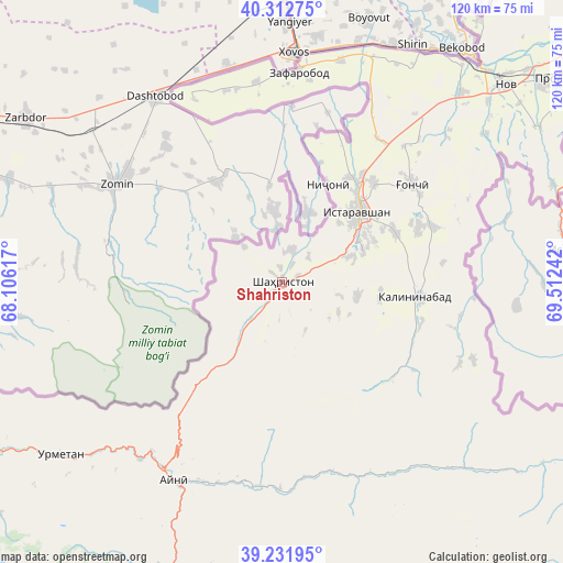
Shahriston GPS coordinates[2]
39° 46' 28.092" North, 68° 48' 33.444" East
| Map corner | latitude | longitude |
|---|---|---|
| Upper-left | 40.31275°, | 68.10617° |
| Center: | 39.77447°, | 68.80929° |
| Lower-right: | 39.23195°, | 69.51242° |
| Map W x H: | 120.2×120.2 km | = 74.7×74.7mi |
| max Lat: | 40.99827° ⇑27.3% North |
| Shahriston: | 39.77447° |
| min Lat: | ⇓72.7% South 36.72484° |
| min Long | Shahriston | max Long |
| 67.60931° | 68.80929° | 73.96674° |
| W 27.3%⇐ | ⇒72.7% E |
Elevation
Elevation of Shahriston is 1438 m = 4718 ft, and this is 475.5 m = 1560 ft above average elevation for this country.
| Max E: |
3607 m = 11834 ft | 19.3% |
| Shahriston | 1438 m 4718 ft | |
| Avg. | 962.5 m = 3158 ft | |
Min E: |
324 m = 1063 ft | 80.7% |
See also: Tajikistan elevation on elevation.city.
Geographical zone
Shahriston is located in North temperate zone (between Tropic of Cancer and the Arctic Circle). Distance of this Northern Tropic circle is 1816.6 km =1128.8 mi to South.| Distance of | km | miles | from Shahriston |
|---|---|---|---|
| North Pole | 5584.6 | 3470.1 | to North |
| Arctic Circle | 2978.7 | 1850.9 | to North |
| Tropic Cancer | 1816.6 | 1128.8 | to South |
| Equator | 4422.5 | 2748 | to South |


Nearby cities:
15 places around Shahriston: (largest is in red/bold)
• Ayní
48.3 km =30 mi,  208°
208°
• Bŭston
94.4 km =58.7 mi,  28°
28°
• Chkalov
91.1 km =56.6 mi,  55°
55°
• Ghafurov
92.4 km =57.4 mi, 57°
• Ghonchí
34.4 km =21.4 mi,  52°
52°
• Istaravshan
22.7 km =14.1 mi, 46°
• Khŭjand
89.3 km =55.5 mi, 50°
• Mehron
57 km =35.4 mi,  134°
134°
• Nov
63.7 km =39.6 mi, 48°
• Pakhtakoron
42.9 km =26.7 mi,  352°
352°
• Palos
99.4 km =61.8 mi, 52°
• Proletar
73.4 km =45.6 mi, 53°
• Quruqsoy
101.5 km =63.1 mi, 28°
• Tagob
104.4 km =64.9 mi,  175°
175°
• Zafarobod
44.8 km =27.8 mi,  4°
4°
Sources, notices
• [Note1] Compared only with cities in Tajikistan existing in our database
• [Src1] Map data: © OpenStreetMap contributors (CC-BY-SA)
• [Src2] Other city data from geonames.org with taken over terms of usage.
• [Src3] Geographical zone / Annual Mean Temperature by Robert A. Rohde @ Wikipedia
