Panjakent geodata
Panjakent (Sughd) is a seat of a second-order administrative division; located in Tajikistan in Asia/Dushanbe (GMT+5) time zone. With population of 35,085 people, there are 9 cities with bigger population in this country. Compared to other cities in Tajikistan, 71.6% of cities are located further ↓South; 100% of cities are located further →East and 62.5% of cities have lower elevation than Panjakent. Note1


Panjakent GPS coordinates[2]
39° 29' 42.864" North, 67° 36' 33.516" East
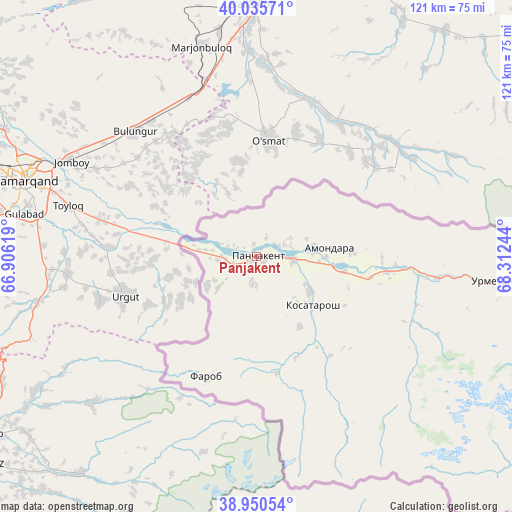
| Map corner | latitude | longitude |
|---|---|---|
| Upper-left | 40.03571°, | 66.90619° |
| Center: | 39.49524°, | 67.60931° |
| Lower-right: | 38.95054°, | 68.31244° |
| Map W x H: | 120.7×120.7 km | = 75×75mi |
| max Lat: | 40.99827° ⇑28.4% North |
| Panjakent: | 39.49524° |
| min Lat: | ⇓71.6% South 36.72484° |
| min Long | Panjakent | max Long |
| 67.60931° | 67.60931° | 73.96674° |
| W 0%⇐ | ⇒100% E |
Elevation
Elevation of Panjakent is 998 m = 3274 ft, and this is 35.5 m = 116 ft above average elevation for this country.
| Max E: |
3607 m = 11834 ft | 37.5% |
| Panjakent | 998 m 3274 ft | |
| Avg. | 962.5 m = 3158 ft | |
Min E: |
324 m = 1063 ft | 62.5% |
See also: Tajikistan elevation on elevation.city.
Geographical zone
Panjakent is located in North temperate zone (between Tropic of Cancer and the Arctic Circle). Distance of this Northern Tropic circle is 1785.5 km =1109.5 mi to South.| Distance of | km | miles | from Panjakent |
|---|---|---|---|
| North Pole | 5615.6 | 3489.4 | to North |
| Arctic Circle | 3009.7 | 1870.1 | to North |
| Tropic Cancer | 1785.5 | 1109.5 | to South |
| Equator | 4391.5 | 2728.8 | to South |


Nearby cities:
15 places around Panjakent: (largest is in red/bold)
• Ayní
80.5 km =50 mi,  98°
98°
• Boshkengash
154.2 km =95.8 mi,  137°
137°
• Dushanbe
146.9 km =91.3 mi, 136°
• Ghonchí
140 km =87 mi,  68°
68°
• Hisor
135.1 km =83.9 mi, 142°
• Istaravshan
128 km =79.5 mi, 68°
• Khodzha-Maston
121.1 km =75.2 mi,  133°
133°
• Mehron
144.3 km =89.7 mi,  93°
93°
• Pakhtakoron
121.8 km =75.7 mi,  52°
52°
• Shahrinav
120.4 km =74.8 mi,  148°
148°
• Shahriston
107.3 km =66.7 mi, 73°
• Tagob
133 km =82.6 mi,  123°
123°
• Tursunzoda
121.8 km =75.7 mi, 153°
• Varzob
131.5 km =81.7 mi, 127°
• Zafarobod
130 km =80.8 mi, 54°
In other languages:
- In France: Pendjikent
- In German: Pandschakent
- In Russian: Пенджикент
- In Chinese: 彭吉肯特
Sources, notices
• [Note1] Compared only with cities in Tajikistan existing in our database
• [Src1] Map data: © OpenStreetMap contributors (CC-BY-SA)
• [Src2] Other city data from geonames.org with taken over terms of usage.
• [Src3] Geographical zone / Annual Mean Temperature by Robert A. Rohde @ Wikipedia
