Ishqoshim geodata
Ishqoshim (Gorno-Badakhshan) is a seat of a second-order administrative division; located in Tajikistan in Asia/Dushanbe (GMT+5) time zone. With population of 26,000 people, there are 11 cities with bigger population in this country. Compared to other cities in Tajikistan, 100% of cities are located further ↑North; 97.7% of cities are located further ←West and 97.7% of cities have lower elevation than Ishqoshim. Note1


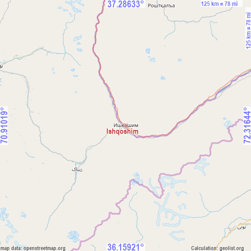
Ishqoshim GPS coordinates[2]
36° 43' 29.424" North, 71° 36' 47.916" East
| Map corner | latitude | longitude |
|---|---|---|
| Upper-left | 37.28633°, | 70.91019° |
| Center: | 36.72484°, | 71.61331° |
| Lower-right: | 36.15921°, | 72.31644° |
| Map W x H: | 125.3×125.3 km | = 77.9×77.9mi |
| max Lat: | 40.99827° ⇑100% North |
| Ishqoshim: | 36.72484° |
| min Lat: | ⇓0% South 36.72484° |
| min Long | Ishqoshim | max Long |
| 67.60931° | 71.61331° | 73.96674° |
| W 97.7%⇐ | ⇒2.3% E |
Elevation
Elevation of Ishqoshim is 2535 m = 8317 ft, and this is 1572.5 m = 5159 ft above average elevation for this country.
| Max E: |
3607 m = 11834 ft | 2.3% |
| Ishqoshim | 2535 m 8317 ft | |
| Avg. | 962.5 m = 3158 ft | |
Min E: |
324 m = 1063 ft | 97.7% |
See also: Tajikistan elevation on elevation.city.
Geographical zone
Ishqoshim is located in North temperate zone (between Tropic of Cancer and the Arctic Circle). Distance of this Northern Tropic circle is 1477.5 km =918.1 mi to South.| Distance of | km | miles | from Ishqoshim |
|---|---|---|---|
| North Pole | 5923.6 | 3680.8 | to North |
| Arctic Circle | 3317.8 | 2061.6 | to North |
| Tropic Cancer | 1477.5 | 918.1 | to South |
| Equator | 4083.4 | 2537.3 | to South |


Nearby cities:
15 places around Ishqoshim: (largest is in red/bold)
• Chubek
195.9 km =121.7 mi,  300°
300°
• Farkhor
213.7 km =132.8 mi,  293°
293°
• Khorugh
85.2 km =52.9 mi,  356°
356°
• Khovaling
230.6 km =143.3 mi,  321°
321°
• Kŭlob
208.9 km =129.8 mi,  309°
309°
• Moskva
204.3 km =126.9 mi, 300°
• Mŭ’minobod
207.6 km =129 mi, 317°
• Panj
230.4 km =143.2 mi,  284°
284°
• Qalaikhumb
205.5 km =127.7 mi,  339°
339°
• Roshtqal’a
62.2 km =38.6 mi,  17°
17°
• Rŭshon
135.7 km =84.3 mi, 357°
• Shŭrobod
185.9 km =115.5 mi, 311°
• Sovet
231.5 km =143.8 mi, 309°
• Vanj
183.5 km =114 mi, 355°
• Vose’
211.6 km =131.5 mi, 304°
Sources, notices
• [Note1] Compared only with cities in Tajikistan existing in our database
• [Src1] Map data: © OpenStreetMap contributors (CC-BY-SA)
• [Src2] Other city data from geonames.org with taken over terms of usage.
• [Src3] Geographical zone / Annual Mean Temperature by Robert A. Rohde @ Wikipedia
