Tataouine geodata
Tataouine is a seat of a first-order administrative division; located in Tunisia in Africa/Tunis (GMT+1) time zone. With population of 62,577 people, there are 18 cities with bigger population in this country. Compared to other cities in Tunisia, 99.3% of cities are located further ↑North; 60.1% of cities are located further ←West and 78.3% of cities have lower elevation than Tataouine. Note1


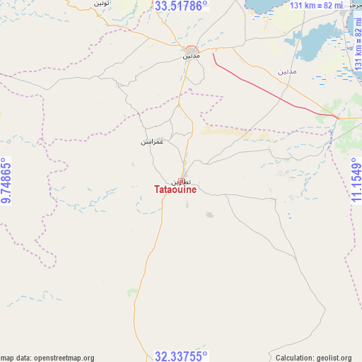
Tataouine GPS coordinates[2]
32° 55' 46.812" North, 10° 27' 6.372" East
| Map corner | latitude | longitude |
|---|---|---|
| Upper-left | 33.51786°, | 9.74865° |
| Center: | 32.92967°, | 10.45177° |
| Lower-right: | 32.33755°, | 11.1549° |
| Map W x H: | 131.2×131.2 km | = 81.5×81.5mi |
| max Lat: | 37.27442° ⇑99.3% North |
| Tataouine: | 32.92967° |
| min Lat: | ⇓0.7% South 32.31662° |
| min Long | Tataouine | max Long |
| 7.87765° | 10.45177° | 11.21965° |
| W 60.1%⇐ | ⇒39.9% E |
Elevation
Elevation of Tataouine is 238 m = 781 ft, and this is 88.6 m = 291 ft above average elevation for this country.
| Max E: |
999 m = 3278 ft | 21.7% |
| Tataouine | 238 m 781 ft | |
| Avg. | 149.4 m = 490 ft | |
Min E: |
-6 m = -20 ft | 78.3% |
See also: Tataouine elevation on elevation.city.
Geographical zone
Tataouine is located in North temperate zone (between Tropic of Cancer and the Arctic Circle). Distance of this Northern Tropic circle is 1055.5 km =655.9 mi to South.| Distance of | km | miles | from Tataouine |
|---|---|---|---|
| North Pole | 6345.6 | 3943 | to North |
| Arctic Circle | 3739.7 | 2323.7 | to North |
| Tropic Cancer | 1055.5 | 655.9 | to South |
| Equator | 3661.4 | 2275.1 | to South |


Nearby cities:
15 places around Tataouine: (largest is in red/bold)
• Ben Gardane
75.2 km =46.7 mi,  72°
72°
• Beni Kheddache
43 km =26.7 mi,  326°
326°
• Bou Attouche
124.3 km =77.2 mi, 330°
• Douz
145.9 km =90.7 mi,  294°
294°
• El Golaa
147.9 km =91.9 mi, 294°
• El Hamma
123 km =76.4 mi, 330°
• Erriadh
105.9 km =65.8 mi,  20°
20°
• Gabès
110.8 km =68.8 mi,  342°
342°
• Houmt El Souk
111.7 km =69.4 mi, 19°
• Jemna
151.8 km =94.3 mi,  298°
298°
• Matmata
81.7 km =50.8 mi, 326°
• Medenine
47.6 km =29.6 mi,  6°
6°
• Midoun
109.8 km =68.2 mi,  27°
27°
• Remada
68.4 km =42.5 mi,  184°
184°
• Zarzis
88.6 km =55.1 mi,  43°
43°
Sources, notices
• [Note1] Compared only with cities in Tunisia existing in our database
• [Src1] Map data: © OpenStreetMap contributors (CC-BY-SA)
• [Src2] Other city data from geonames.org with taken over terms of usage.
• [Src3] Geographical zone / Annual Mean Temperature by Robert A. Rohde @ Wikipedia
