Taşburun geodata
Taşburun (Iğdır) is a seat of a third-order administrative division; located in Turkey in Europe/Istanbul (GMT+3) time zone. In our database, there are 1323 cities with bigger population. Compared to other cities in Turkey, 68.8% of cities are located further ↓South; 99.8% of cities are located further ←West and 57.7% of cities have lower elevation than Taşburun. Note1


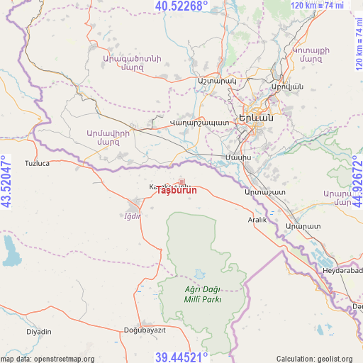
Taşburun GPS coordinates[2]
39° 59' 9.852" North, 44° 13' 24.924" East
| Map corner | latitude | longitude |
|---|---|---|
| Upper-left | 40.52268°, | 43.52047° |
| Center: | 39.98607°, | 44.22359° |
| Lower-right: | 39.44521°, | 44.92672° |
| Map W x H: | 119.8×119.8 km | = 74.4×74.4mi |
| max Lat: | 42.02683° ⇑31.2% North |
| Taşburun: | 39.98607° |
| min Lat: | ⇓68.8% South 35.9025° |
| min Long | Taşburun | max Long |
| 25.90902° | 44.22359° | 44.60099° |
| W 99.8%⇐ | ⇒0.2% E |
Elevation
Elevation of Taşburun is 839 m = 2753 ft, and this is 121.6 m = 399 ft above average elevation for this country.
| Max E: |
2682 m = 8799 ft | 42.3% |
| Taşburun | 839 m 2753 ft | |
| Avg. | 717.4 m = 2354 ft | |
Min E: |
0 m = 0 ft | 57.7% |
See also: Turkey elevation on elevation.city.
Geographical zone
Taşburun is located in North temperate zone (between Tropic of Cancer and the Arctic Circle). Distance of this Northern Tropic circle is 1840.1 km =1143.4 mi to South.| Distance of | km | miles | from Taşburun |
|---|---|---|---|
| North Pole | 5561 | 3455.4 | to North |
| Arctic Circle | 2955.1 | 1836.2 | to North |
| Tropic Cancer | 1840.1 | 1143.4 | to South |
| Equator | 4446 | 2762.6 | to South |


Nearby cities:
15 places around Taşburun: (largest is in red/bold)
• Aralık
28.2 km =17.5 mi,  116°
116°
• Başgedikler
94 km =58.4 mi,  320°
320°
• Cumaçay
88.7 km =55.1 mi,  264°
264°
• Digor
81.2 km =50.5 mi,  301°
301°
• Diyadin
68.4 km =42.5 mi,  223°
223°
• Doğubayazıt
50.3 km =31.3 mi,  193°
193°
• Gaziler
66.5 km =41.3 mi,  279°
279°
• Iğdır
16.7 km =10.4 mi,  245°
245°
• Karakoyunlu
52.2 km =32.4 mi, 255°
• Kağızman
94.6 km =58.8 mi, 281°
• Murat
91 km =56.5 mi, 247°
• Suluçem
47.7 km =29.6 mi,  227°
227°
• Taşlıçay
83.1 km =51.6 mi,  241°
241°
• Tuzluca
49 km =30.4 mi, 276°
• Çaldıran
97.5 km =60.6 mi,  195°
195°
Sources, notices
• [Note1] Compared only with cities in Turkey existing in our database
• [Src1] Map data: © OpenStreetMap contributors (CC-BY-SA)
• [Src2] Other city data from geonames.org with taken over terms of usage.
• [Src3] Geographical zone / Annual Mean Temperature by Robert A. Rohde @ Wikipedia
