Aralık geodata
Aralık (Iğdır) is a seat of a second-order administrative division; located in Turkey in Europe/Istanbul (GMT+3) time zone. In our database, there are 1323 cities with bigger population. Compared to other cities in Turkey, 67% of cities are located further ↓South; 99.9% of cities are located further ←West and 56.4% of cities have lower elevation than Aralık. Note1


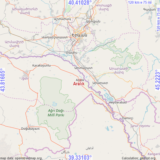
Aralık GPS coordinates[2]
39° 52' 22.008" North, 44° 31' 9.012" East
| Map corner | latitude | longitude |
|---|---|---|
| Upper-left | 40.41028°, | 43.81605° |
| Center: | 39.87278°, | 44.51917° |
| Lower-right: | 39.33103°, | 45.2223° |
| Map W x H: | 120×120 km | = 74.6×74.6mi |
| max Lat: | 42.02683° ⇑33% North |
| Aralık: | 39.87278° |
| min Lat: | ⇓67% South 35.9025° |
| min Long | Aralık | max Long |
| 25.90902° | 44.51917° | 44.60099° |
| W 99.9%⇐ | ⇒0.099999999999994% E |
Elevation
Elevation of Aralık is 817 m = 2680 ft, and this is 99.6 m = 327 ft above average elevation for this country.
| Max E: |
2682 m = 8799 ft | 43.6% |
| Aralık | 817 m 2680 ft | |
| Avg. | 717.4 m = 2354 ft | |
Min E: |
0 m = 0 ft | 56.4% |
See also: Turkey elevation on elevation.city.
Geographical zone
Aralık is located in North temperate zone (between Tropic of Cancer and the Arctic Circle). Distance of this Northern Tropic circle is 1827.5 km =1135.6 mi to South.| Distance of | km | miles | from Aralık |
|---|---|---|---|
| North Pole | 5573.6 | 3463.3 | to North |
| Arctic Circle | 2967.7 | 1844 | to North |
| Tropic Cancer | 1827.5 | 1135.6 | to South |
| Equator | 4433.4 | 2754.8 | to South |


Nearby cities:
15 places around Aralık: (largest is in red/bold)
• Başgedikler
120.2 km =74.7 mi,  315°
315°
• Cumaçay
113.8 km =70.7 mi,  272°
272°
• Digor
109.3 km =67.9 mi,  300°
300°
• Diyadin
81.4 km =50.6 mi,  243°
243°
• Doğubayazıt
51.9 km =32.2 mi,  225°
225°
• Gaziler
93.8 km =58.3 mi,  284°
284°
• Iğdır
40.8 km =25.4 mi, 277°
• Karakoyunlu
75.9 km =47.2 mi, 269°
• Muradiye
118.6 km =73.7 mi,  213°
213°
• Murat
111.6 km =69.3 mi,  258°
258°
• Suluçem
63.4 km =39.4 mi,  251°
251°
• Taşburun
28.2 km =17.5 mi, 296°
• Taşlıçay
102 km =63.4 mi, 254°
• Tuzluca
76.2 km =47.3 mi, 284°
• Çaldıran
96.5 km =60 mi, 212°
Sources, notices
• [Note1] Compared only with cities in Turkey existing in our database
• [Src1] Map data: © OpenStreetMap contributors (CC-BY-SA)
• [Src2] Other city data from geonames.org with taken over terms of usage.
• [Src3] Geographical zone / Annual Mean Temperature by Robert A. Rohde @ Wikipedia
