Taşpınar geodata
Taşpınar (Aksaray) is a seat of a third-order administrative division; located in Turkey in Europe/Istanbul (GMT+3) time zone. In our database, there are 1323 cities with bigger population. Compared to other cities in Turkey, 58.3% of cities are located further ↑North; 58.3% of cities are located further →East and 72% of cities have lower elevation than Taşpınar. Note1


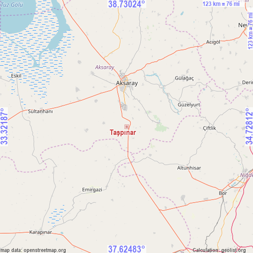
Taşpınar GPS coordinates[2]
38° 10' 46.668" North, 34° 1' 29.964" East
| Map corner | latitude | longitude |
|---|---|---|
| Upper-left | 38.73024°, | 33.32187° |
| Center: | 38.17963°, | 34.02499° |
| Lower-right: | 37.62483°, | 34.72812° |
| Map W x H: | 122.9×122.9 km | = 76.4×76.4mi |
| max Lat: | 42.02683° ⇑58.3% North |
| Taşpınar: | 38.17963° |
| min Lat: | ⇓41.7% South 35.9025° |
| min Long | Taşpınar | max Long |
| 25.90902° | 34.02499° | 44.60099° |
| W 41.7%⇐ | ⇒58.3% E |
Elevation
Elevation of Taşpınar is 1056 m = 3465 ft, and this is 338.6 m = 1111 ft above average elevation for this country.
| Max E: |
2682 m = 8799 ft | 28% |
| Taşpınar | 1056 m 3465 ft | |
| Avg. | 717.4 m = 2354 ft | |
Min E: |
0 m = 0 ft | 72% |
See also: Turkey elevation on elevation.city.
Geographical zone
Taşpınar is located in North temperate zone (between Tropic of Cancer and the Arctic Circle). Distance of this Northern Tropic circle is 1639.3 km =1018.6 mi to South.| Distance of | km | miles | from Taşpınar |
|---|---|---|---|
| North Pole | 5761.9 | 3580.3 | to North |
| Arctic Circle | 3156 | 1961 | to North |
| Tropic Cancer | 1639.3 | 1018.6 | to South |
| Equator | 4245.2 | 2637.8 | to South |


Nearby cities:
15 places around Taşpınar: (largest is in red/bold)
• Acıgöl
59 km =36.7 mi,  45°
45°
• Acıpınar
41.4 km =25.7 mi,  338°
338°
• Aksaray
21.5 km =13.4 mi,  0°
0°
• Altunhisar
37 km =23 mi,  124°
124°
• Balcı
61 km =37.9 mi,  6°
6°
• Beyviran
39.5 km =24.5 mi,  201°
201°
• Bor
56.7 km =35.2 mi, 124°
• Emirgazi
35 km =21.7 mi,  208°
208°
• Eskil
58.8 km =36.5 mi,  294°
294°
• Gülağaç
36.9 km =22.9 mi, 49°
• Güzelyurt
32.2 km =20 mi,  70°
70°
• Ortaköy
62 km =38.5 mi, 1°
• Sultanhanı
42.2 km =26.2 mi,  280°
280°
• Yeşilova
30.3 km =18.8 mi,  327°
327°
• Çiftlik
40.2 km =25 mi,  90°
90°
Sources, notices
• [Note1] Compared only with cities in Turkey existing in our database
• [Src1] Map data: © OpenStreetMap contributors (CC-BY-SA)
• [Src2] Other city data from geonames.org with taken over terms of usage.
• [Src3] Geographical zone / Annual Mean Temperature by Robert A. Rohde @ Wikipedia
