Aksaray geodata
Aksaray is a seat of a first-order administrative division; located in Turkey in Europe/Istanbul (GMT+3) time zone. With population of 152,201 people, there are 63 cities with bigger population in this country. Compared to other cities in Turkey, 54.9% of cities are located further ↑North; 58.3% of cities are located further →East and 66% of cities have lower elevation than Aksaray. Note1


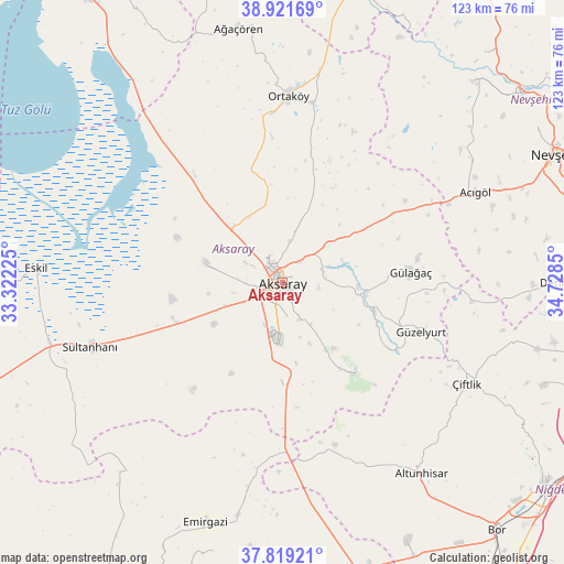
Aksaray GPS coordinates[2]
38° 22' 21.18" North, 34° 1' 31.332" East
| Map corner | latitude | longitude |
|---|---|---|
| Upper-left | 38.92169°, | 33.32225° |
| Center: | 38.37255°, | 34.02537° |
| Lower-right: | 37.81921°, | 34.7285° |
| Map W x H: | 122.6×122.6 km | = 76.2×76.2mi |
| max Lat: | 42.02683° ⇑54.9% North |
| Aksaray: | 38.37255° |
| min Lat: | ⇓45.1% South 35.9025° |
| min Long | Aksaray | max Long |
| 25.90902° | 34.02537° | 44.60099° |
| W 41.7%⇐ | ⇒58.3% E |
Elevation
Elevation of Aksaray is 976 m = 3202 ft, and this is 258.6 m = 848 ft above average elevation for this country.
| Max E: |
2682 m = 8799 ft | 34% |
| Aksaray | 976 m 3202 ft | |
| Avg. | 717.4 m = 2354 ft | |
Min E: |
0 m = 0 ft | 66% |
See also: Aksaray elevation on elevation.city.
Geographical zone
Aksaray is located in North temperate zone (between Tropic of Cancer and the Arctic Circle). Distance of this Northern Tropic circle is 1660.7 km =1031.9 mi to South.| Distance of | km | miles | from Aksaray |
|---|---|---|---|
| North Pole | 5740.4 | 3566.9 | to North |
| Arctic Circle | 3134.5 | 1947.7 | to North |
| Tropic Cancer | 1660.7 | 1031.9 | to South |
| Equator | 4266.6 | 2651.1 | to South |


Nearby cities:
15 places around Aksaray: (largest is in red/bold)
• Acıgöl
46.5 km =28.9 mi,  64°
64°
• Acıpınar
22.8 km =14.2 mi,  318°
318°
• Altunhisar
52.1 km =32.4 mi,  144°
144°
• Ağaçören
56.6 km =35.2 mi,  350°
350°
• Balcı
39.8 km =24.7 mi,  9°
9°
• Beyviran
59.9 km =37.2 mi,  193°
193°
• Emirgazi
54.8 km =34.1 mi,  197°
197°
• Eskil
53.5 km =33.2 mi,  273°
273°
• Gülağaç
28 km =17.4 mi,  84°
84°
• Güzelyurt
32 km =19.9 mi,  109°
109°
• Ortaköy
40.6 km =25.2 mi,  1°
1°
• Sultanhanı
43.8 km =27.2 mi,  251°
251°
• Taşpınar
21.5 km =13.4 mi,  180°
180°
• Yeşilova
16.8 km =10.4 mi,  284°
284°
• Çiftlik
45.7 km =28.4 mi,  118°
118°
Sources, notices
• [Note1] Compared only with cities in Turkey existing in our database
• [Src1] Map data: © OpenStreetMap contributors (CC-BY-SA)
• [Src2] Other city data from geonames.org with taken over terms of usage.
• [Src3] Geographical zone / Annual Mean Temperature by Robert A. Rohde @ Wikipedia
