Acıpınar geodata
Acıpınar (Aksaray) is a seat of a third-order administrative division; located in Turkey in Europe/Istanbul (GMT+3) time zone. In our database, there are 1323 cities with bigger population. Compared to other cities in Turkey, 52.5% of cities are located further ↑North; 58.9% of cities are located further →East and 67.5% of cities have lower elevation than Acıpınar. Note1


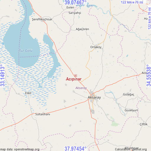
Acıpınar GPS coordinates[2]
38° 31' 36.156" North, 33° 51' 8.1" East
| Map corner | latitude | longitude |
|---|---|---|
| Upper-left | 39.07467°, | 33.14913° |
| Center: | 38.52671°, | 33.85225° |
| Lower-right: | 37.97454°, | 34.55538° |
| Map W x H: | 122.3×122.3 km | = 76×76mi |
| max Lat: | 42.02683° ⇑52.5% North |
| Acıpınar: | 38.52671° |
| min Lat: | ⇓47.5% South 35.9025° |
| min Long | Acıpınar | max Long |
| 25.90902° | 33.85225° | 44.60099° |
| W 41.1%⇐ | ⇒58.9% E |
Elevation
Elevation of Acıpınar is 993 m = 3258 ft, and this is 275.6 m = 904 ft above average elevation for this country.
| Max E: |
2682 m = 8799 ft | 32.5% |
| Acıpınar | 993 m 3258 ft | |
| Avg. | 717.4 m = 2354 ft | |
Min E: |
0 m = 0 ft | 67.5% |
See also: Turkey elevation on elevation.city.
Geographical zone
Acıpınar is located in North temperate zone (between Tropic of Cancer and the Arctic Circle). Distance of this Northern Tropic circle is 1677.8 km =1042.5 mi to South.| Distance of | km | miles | from Acıpınar |
|---|---|---|---|
| North Pole | 5723.3 | 3556.3 | to North |
| Arctic Circle | 3117.4 | 1937.1 | to North |
| Tropic Cancer | 1677.8 | 1042.5 | to South |
| Equator | 4283.8 | 2661.8 | to South |


Nearby cities:
15 places around Acıpınar: (largest is in red/bold)
• Acıgöl
57.2 km =35.5 mi,  87°
87°
• Aksaray
22.8 km =14.2 mi,  138°
138°
• Ağaçören
39.1 km =24.3 mi,  8°
8°
• Balcı
30.9 km =19.2 mi,  44°
44°
• Eskil
40.7 km =25.3 mi,  250°
250°
• Evren
55.4 km =34.4 mi,  355°
355°
• Gülağaç
45.4 km =28.2 mi,  108°
108°
• Güzelyurt
53.1 km =33 mi,  121°
121°
• Ortaköy
28.5 km =17.7 mi,  34°
34°
• Sarıyahşi
50.8 km =31.6 mi, 358°
• Sultanhanı
40.8 km =25.4 mi,  220°
220°
• Taşpınar
41.4 km =25.7 mi,  158°
158°
• Yeşilova
13.1 km =8.1 mi,  185°
185°
• Çiftlik
67.6 km =42 mi,  125°
125°
• Şereflikoçhisar
53.3 km =33.1 mi,  329°
329°
Sources, notices
• [Note1] Compared only with cities in Turkey existing in our database
• [Src1] Map data: © OpenStreetMap contributors (CC-BY-SA)
• [Src2] Other city data from geonames.org with taken over terms of usage.
• [Src3] Geographical zone / Annual Mean Temperature by Robert A. Rohde @ Wikipedia
