Şereflikoçhisar geodata
Şereflikoçhisar (Ankara) is a populated place; located in Turkey in Europe/Istanbul (GMT+3) time zone. With population of 44,101 people, there are 196 cities with bigger population in this country. Compared to other cities in Turkey, 53.6% of cities are located further ↓South; 60.2% of cities are located further →East and 64.2% of cities have lower elevation than Şereflikoçhisar. Note1


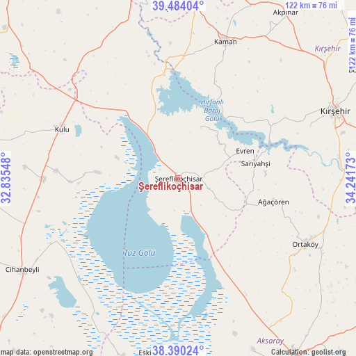
Şereflikoçhisar GPS coordinates[2]
38° 56' 21.3" North, 33° 32' 18.96" East
| Map corner | latitude | longitude |
|---|---|---|
| Upper-left | 39.48404°, | 32.83548° |
| Center: | 38.93925°, | 33.5386° |
| Lower-right: | 38.39024°, | 34.24173° |
| Map W x H: | 121.6×121.6 km | = 75.6×75.6mi |
| max Lat: | 42.02683° ⇑46.4% North |
| Şereflikoçhisar: | 38.93925° |
| min Lat: | ⇓53.6% South 35.9025° |
| min Long | Şereflikoçhis | max Long |
| 25.90902° | 33.5386° | 44.60099° |
| W 39.8%⇐ | ⇒60.2% E |
Elevation
Elevation of Şereflikoçhisar is 948 m = 3110 ft, and this is 230.6 m = 757 ft above average elevation for this country.
| Max E: |
2682 m = 8799 ft | 35.8% |
| Şereflikoçhisar | 948 m 3110 ft | |
| Avg. | 717.4 m = 2354 ft | |
Min E: |
0 m = 0 ft | 64.2% |
See also: Şereflikoçhisar elevation on elevation.city.
Geographical zone
Şereflikoçhisar is located in North temperate zone (between Tropic of Cancer and the Arctic Circle). Distance of this Northern Tropic circle is 1723.7 km =1071.1 mi to South.| Distance of | km | miles | from Şereflikoçhisar |
|---|---|---|---|
| North Pole | 5677.4 | 3527.8 | to North |
| Arctic Circle | 3071.5 | 1908.5 | to North |
| Tropic Cancer | 1723.7 | 1071.1 | to South |
| Equator | 4329.6 | 2690.3 | to South |


Nearby cities:
15 places around Şereflikoçhisar: (largest is in red/bold)
• Acıpınar
53.3 km =33.1 mi,  149°
149°
• Ağaçören
33.5 km =20.8 mi,  102°
102°
• Balcı
54.2 km =33.7 mi,  116°
116°
• Cihanbeyli
61.6 km =38.3 mi,  239°
239°
• Eskil
60.8 km =37.8 mi,  190°
190°
• Evren
25 km =15.5 mi,  67°
67°
• Kaman
49.2 km =30.6 mi,  18°
18°
• Kulu
43.3 km =26.9 mi,  293°
293°
• Kırşehir
58.7 km =36.5 mi, 66°
• Ortaköy
48.8 km =30.3 mi, 117°
• Sarıyahşi
26.6 km =16.5 mi,  79°
79°
• Savcılı
34.5 km =21.4 mi, 20°
• Yeniceoba
65.4 km =40.6 mi,  263°
263°
• Yeşilova
64.4 km =40 mi,  156°
156°
• Çelebi
58.4 km =36.3 mi,  358°
358°
Sources, notices
• [Note1] Compared only with cities in Turkey existing in our database
• [Src1] Map data: © OpenStreetMap contributors (CC-BY-SA)
• [Src2] Other city data from geonames.org with taken over terms of usage.
• [Src3] Geographical zone / Annual Mean Temperature by Robert A. Rohde @ Wikipedia
