Kazancı geodata
Kazancı (Karaman) is a seat of a third-order administrative division; located in Turkey in Europe/Istanbul (GMT+3) time zone. In our database, there are 1323 cities with bigger population. Compared to other cities in Turkey, 96.9% of cities are located further ↑North; 62.8% of cities are located further →East and 77.5% of cities have lower elevation than Kazancı. Note1


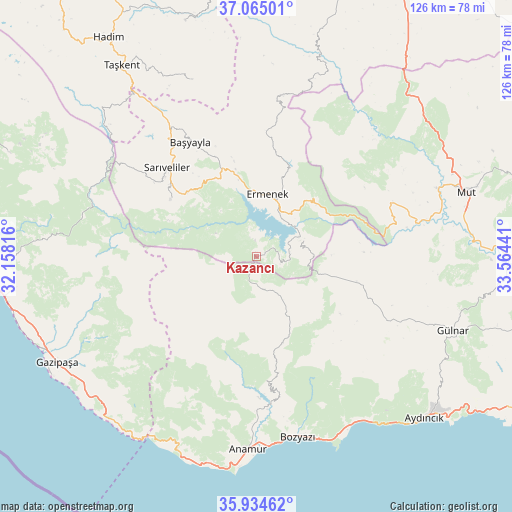
Kazancı GPS coordinates[2]
36° 30' 6.768" North, 32° 51' 40.608" East
| Map corner | latitude | longitude |
|---|---|---|
| Upper-left | 37.06501°, | 32.15816° |
| Center: | 36.50188°, | 32.86128° |
| Lower-right: | 35.93462°, | 33.56441° |
| Map W x H: | 125.7×125.7 km | = 78.1×78.1mi |
| max Lat: | 42.02683° ⇑96.9% North |
| Kazancı: | 36.50188° |
| min Lat: | ⇓3.1% South 35.9025° |
| min Long | Kazancı | max Long |
| 25.90902° | 32.86128° | 44.60099° |
| W 37.2%⇐ | ⇒62.8% E |
Elevation
Elevation of Kazancı is 1143 m = 3750 ft, and this is 425.6 m = 1396 ft above average elevation for this country.
| Max E: |
2682 m = 8799 ft | 22.5% |
| Kazancı | 1143 m 3750 ft | |
| Avg. | 717.4 m = 2354 ft | |
Min E: |
0 m = 0 ft | 77.5% |
See also: Turkey elevation on elevation.city.
Geographical zone
Kazancı is located in North temperate zone (between Tropic of Cancer and the Arctic Circle). Distance of this Northern Tropic circle is 1452.7 km =902.7 mi to South.| Distance of | km | miles | from Kazancı |
|---|---|---|---|
| North Pole | 5948.4 | 3696.2 | to North |
| Arctic Circle | 3342.5 | 2076.9 | to North |
| Tropic Cancer | 1452.7 | 902.7 | to South |
| Equator | 4058.6 | 2521.9 | to South |


Nearby cities:
15 places around Kazancı: (largest is in red/bold)
• Anamur
47.5 km =29.5 mi,  182°
182°
• Aydıncık
57.2 km =35.5 mi,  134°
134°
• Başyayla
32.3 km =20.1 mi,  329°
329°
• Bozyazı
44.7 km =27.8 mi,  168°
168°
• Bucakkışla
52.3 km =32.5 mi,  15°
15°
• Demirtaş
60.4 km =37.5 mi,  261°
261°
• Ermenek
15.6 km =9.7 mi,  10°
10°
• Gazipaşa
55.1 km =34.2 mi,  242°
242°
• Göktepe
25.4 km =15.8 mi,  303°
303°
• Gülnar
51.3 km =31.9 mi,  110°
110°
• Hadim
64.9 km =40.3 mi, 326°
• Mut
53.9 km =33.5 mi,  72°
72°
• Sarıveliler
31.1 km =19.3 mi,  314°
314°
• Taşkent
57.4 km =35.7 mi,  324°
324°
• Tepebaşı
22.1 km =13.7 mi, 325°
Sources, notices
• [Note1] Compared only with cities in Turkey existing in our database
• [Src1] Map data: © OpenStreetMap contributors (CC-BY-SA)
• [Src2] Other city data from geonames.org with taken over terms of usage.
• [Src3] Geographical zone / Annual Mean Temperature by Robert A. Rohde @ Wikipedia
