Gülnar geodata
Gülnar (Mersin) is a seat of a second-order administrative division; located in Turkey in Europe/Istanbul (GMT+3) time zone. With population of 12,385 people, there are 443 cities with bigger population in this country. Compared to other cities in Turkey, 97.6% of cities are located further ↑North; 60.9% of cities are located further →East and 66.1% of cities have lower elevation than Gülnar. Note1


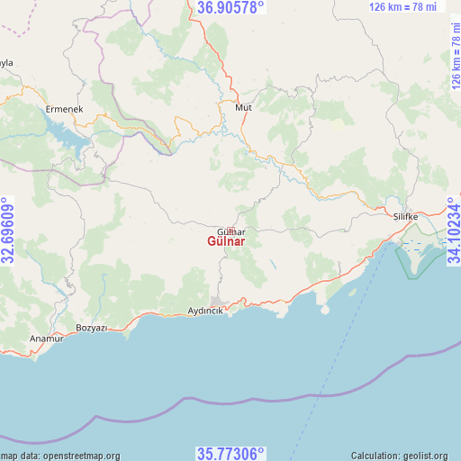
Gülnar GPS coordinates[2]
36° 20' 29.328" North, 33° 23' 57.156" East
| Map corner | latitude | longitude |
|---|---|---|
| Upper-left | 36.90578°, | 32.69609° |
| Center: | 36.34148°, | 33.39921° |
| Lower-right: | 35.77306°, | 34.10234° |
| Map W x H: | 125.9×125.9 km | = 78.2×78.2mi |
| max Lat: | 42.02683° ⇑97.6% North |
| Gülnar: | 36.34148° |
| min Lat: | ⇓2.4% South 35.9025° |
| min Long | Gülnar | max Long |
| 25.90902° | 33.39921° | 44.60099° |
| W 39.1%⇐ | ⇒60.9% E |
Elevation
Elevation of Gülnar is 977 m = 3205 ft, and this is 259.6 m = 852 ft above average elevation for this country.
| Max E: |
2682 m = 8799 ft | 33.9% |
| Gülnar | 977 m 3205 ft | |
| Avg. | 717.4 m = 2354 ft | |
Min E: |
0 m = 0 ft | 66.1% |
See also: Turkey elevation on elevation.city.
Geographical zone
Gülnar is located in North temperate zone (between Tropic of Cancer and the Arctic Circle). Distance of this Northern Tropic circle is 1434.9 km =891.6 mi to South.| Distance of | km | miles | from Gülnar |
|---|---|---|---|
| North Pole | 5966.3 | 3707.3 | to North |
| Arctic Circle | 3360.4 | 2088.1 | to North |
| Tropic Cancer | 1434.9 | 891.6 | to South |
| Equator | 4040.8 | 2510.8 | to South |


Nearby cities:
15 places around Gülnar: (largest is in red/bold)
• Akdere
33.4 km =20.8 mi,  109°
109°
• Anamur
58.5 km =36.4 mi,  239°
239°
• Aydıncık
23.1 km =14.4 mi,  197°
197°
• Bozyazı
47.1 km =29.3 mi, 236°
• Bucakkışla
76 km =47.2 mi,  333°
333°
• Ermenek
56.2 km =34.9 mi,  306°
306°
• Kazancı
51.3 km =31.9 mi,  290°
290°
• Kırobası
59.5 km =37 mi,  44°
44°
• Kızkalesi
67.8 km =42.1 mi,  78°
78°
• Mut
33.8 km =21 mi,  6°
6°
• Ovacık
23.6 km =14.7 mi,  143°
143°
• Sarıkavak
34.4 km =21.4 mi, 39°
• Silifke
48.1 km =29.9 mi,  85°
85°
• Taşucu
43.3 km =26.9 mi, 92°
• Tepebaşı
70.5 km =43.8 mi,  300°
300°
Sources, notices
• [Note1] Compared only with cities in Turkey existing in our database
• [Src1] Map data: © OpenStreetMap contributors (CC-BY-SA)
• [Src2] Other city data from geonames.org with taken over terms of usage.
• [Src3] Geographical zone / Annual Mean Temperature by Robert A. Rohde @ Wikipedia
