Gazipaşa geodata
Gazipaşa (Antalya) is a seat of a second-order administrative division; located in Turkey in Europe/Istanbul (GMT+3) time zone. With population of 18,371 people, there are 350 cities with bigger population in this country. Compared to other cities in Turkey, 97.9% of cities are located further ↑North; 65.3% of cities are located further →East and 94.1% of cities have higher elevation than Gazipaşa. Note1


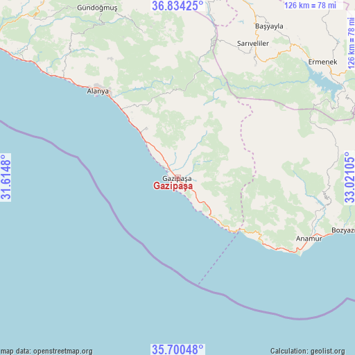
Gazipaşa GPS coordinates[2]
36° 16' 9.912" North, 32° 19' 4.512" East
| Map corner | latitude | longitude |
|---|---|---|
| Upper-left | 36.83425°, | 31.6148° |
| Center: | 36.26942°, | 32.31792° |
| Lower-right: | 35.70048°, | 33.02105° |
| Map W x H: | 126.1×126.1 km | = 78.4×78.4mi |
| max Lat: | 42.02683° ⇑97.9% North |
| Gazipaşa: | 36.26942° |
| min Lat: | ⇓2.1% South 35.9025° |
| min Long | Gazipaşa | max Long |
| 25.90902° | 32.31792° | 44.60099° |
| W 34.7%⇐ | ⇒65.3% E |
Elevation
Elevation of Gazipaşa is 20 m = 66 ft, and this is 697.4 m = 2288 ft below average elevation for this country.
| Max E: |
2682 m = 8799 ft | 94.1% |
| Avg. | 717.4 m = 2354 ft | |
| Gazipaşa | 20 m = 66 ft | |
Min E: |
0 m = 0 ft | 5.9% |
See also: Turkey elevation on elevation.city.
Geographical zone
Gazipaşa is located in North temperate zone (between Tropic of Cancer and the Arctic Circle). Distance of this Northern Tropic circle is 1426.9 km =886.6 mi to South.| Distance of | km | miles | from Gazipaşa |
|---|---|---|---|
| North Pole | 5974.3 | 3712.3 | to North |
| Arctic Circle | 3368.4 | 2093 | to North |
| Tropic Cancer | 1426.9 | 886.6 | to South |
| Equator | 4032.8 | 2505.9 | to South |


Nearby cities:
15 places around Gazipaşa: (largest is in red/bold)
• Alanya
41.7 km =25.9 mi,  316°
316°
• Anamur
51.4 km =31.9 mi,  114°
114°
• Avsallar
63 km =39.1 mi,  308°
308°
• Başyayla
62.8 km =39 mi,  31°
31°
• Bozyazı
60.4 km =37.5 mi, 107°
• Demirtaş
20.7 km =12.9 mi,  327°
327°
• Göktepe
48.2 km =30 mi, 34°
• Güzelbağ
63.8 km =39.6 mi, 324°
• Kazancı
55.1 km =34.2 mi,  62°
62°
• Köprülü
52.8 km =32.8 mi,  346°
346°
• Mahmutlar
32.3 km =20.1 mi, 320°
• Payallar
55.8 km =34.7 mi, 311°
• Sarıveliler
54.3 km =33.7 mi, 28°
• Tepebaşı
57 km =35.4 mi,  39°
39°
• Türkler
57.8 km =35.9 mi, 309°
Sources, notices
• [Note1] Compared only with cities in Turkey existing in our database
• [Src1] Map data: © OpenStreetMap contributors (CC-BY-SA)
• [Src2] Other city data from geonames.org with taken over terms of usage.
• [Src3] Geographical zone / Annual Mean Temperature by Robert A. Rohde @ Wikipedia
