Darende geodata
Darende (Malatya) is a seat of a second-order administrative division; located in Turkey in Europe/Istanbul (GMT+3) time zone. With population of 20,388 people, there are 326 cities with bigger population in this country. Compared to other cities in Turkey, 52.4% of cities are located further ↑North; 58.8% of cities are located further ←West and 70.6% of cities have lower elevation than Darende. Note1


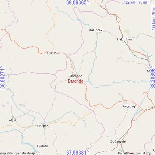
Darende GPS coordinates[2]
38° 32' 44.988" North, 37° 30' 20.988" East
| Map corner | latitude | longitude |
|---|---|---|
| Upper-left | 39.09365°, | 36.80271° |
| Center: | 38.54583°, | 37.50583° |
| Lower-right: | 37.99381°, | 38.20896° |
| Map W x H: | 122.3×122.3 km | = 76×76mi |
| max Lat: | 42.02683° ⇑52.4% North |
| Darende: | 38.54583° |
| min Lat: | ⇓47.6% South 35.9025° |
| min Long | Darende | max Long |
| 25.90902° | 37.50583° | 44.60099° |
| W 58.8%⇐ | ⇒41.2% E |
Elevation
Elevation of Darende is 1036 m = 3399 ft, and this is 318.6 m = 1045 ft above average elevation for this country.
| Max E: |
2682 m = 8799 ft | 29.4% |
| Darende | 1036 m 3399 ft | |
| Avg. | 717.4 m = 2354 ft | |
Min E: |
0 m = 0 ft | 70.6% |
See also: Turkey elevation on elevation.city.
Geographical zone
Darende is located in North temperate zone (between Tropic of Cancer and the Arctic Circle). Distance of this Northern Tropic circle is 1680 km =1043.9 mi to South.| Distance of | km | miles | from Darende |
|---|---|---|---|
| North Pole | 5721.2 | 3555 | to North |
| Arctic Circle | 3115.3 | 1935.8 | to North |
| Tropic Cancer | 1680 | 1043.9 | to South |
| Equator | 4285.9 | 2663.1 | to South |


Nearby cities:
15 places around Darende: (largest is in red/bold)
• Akçadağ
46.5 km =28.9 mi,  119°
119°
• Balaban
11.4 km =7.1 mi,  146°
146°
• Elbistan
46.3 km =28.8 mi,  215°
215°
• Gücük
39.2 km =24.4 mi,  183°
183°
• Gürün
28.3 km =17.6 mi,  313°
313°
• Hasançelebi
55.5 km =34.5 mi,  35°
35°
• Hekimhan
47.5 km =29.5 mi,  50°
50°
• Konakpınar
43.9 km =27.3 mi,  335°
335°
• Kuluncak
39.2 km =24.4 mi,  20°
20°
• Kurşunlu
32.3 km =20.1 mi,  68°
68°
• Kürecik
31 km =19.3 mi,  138°
138°
• Levent
32.6 km =20.3 mi,  111°
111°
• Tanır
53.5 km =33.2 mi,  254°
254°
• Yazyurdu
57.2 km =35.5 mi,  299°
299°
• Yazıhan
58.3 km =36.2 mi,  84°
84°
Sources, notices
• [Note1] Compared only with cities in Turkey existing in our database
• [Src1] Map data: © OpenStreetMap contributors (CC-BY-SA)
• [Src2] Other city data from geonames.org with taken over terms of usage.
• [Src3] Geographical zone / Annual Mean Temperature by Robert A. Rohde @ Wikipedia
