Balaban geodata
Balaban (Malatya) is a seat of a third-order administrative division; located in Turkey in Europe/Istanbul (GMT+3) time zone. In our database, there are 1323 cities with bigger population. Compared to other cities in Turkey, 53.4% of cities are located further ↑North; 59.3% of cities are located further ←West and 74.2% of cities have lower elevation than Balaban. Note1


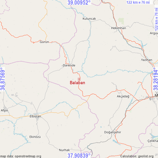
Balaban GPS coordinates[2]
38° 27' 39.816" North, 37° 34' 43.716" East
| Map corner | latitude | longitude |
|---|---|---|
| Upper-left | 39.00952°, | 36.87569° |
| Center: | 38.46106°, | 37.57881° |
| Lower-right: | 37.90839°, | 38.28194° |
| Map W x H: | 122.4×122.4 km | = 76.1×76.1mi |
| max Lat: | 42.02683° ⇑53.4% North |
| Balaban: | 38.46106° |
| min Lat: | ⇓46.6% South 35.9025° |
| min Long | Balaban | max Long |
| 25.90902° | 37.57881° | 44.60099° |
| W 59.3%⇐ | ⇒40.7% E |
Elevation
Elevation of Balaban is 1093 m = 3586 ft, and this is 375.6 m = 1232 ft above average elevation for this country.
| Max E: |
2682 m = 8799 ft | 25.8% |
| Balaban | 1093 m 3586 ft | |
| Avg. | 717.4 m = 2354 ft | |
Min E: |
0 m = 0 ft | 74.2% |
See also: Turkey elevation on elevation.city.
Geographical zone
Balaban is located in North temperate zone (between Tropic of Cancer and the Arctic Circle). Distance of this Northern Tropic circle is 1670.6 km =1038.1 mi to South.| Distance of | km | miles | from Balaban |
|---|---|---|---|
| North Pole | 5730.6 | 3560.8 | to North |
| Arctic Circle | 3124.7 | 1941.6 | to North |
| Tropic Cancer | 1670.6 | 1038.1 | to South |
| Equator | 4276.5 | 2657.3 | to South |


Nearby cities:
15 places around Balaban: (largest is in red/bold)
• Akçadağ
36.7 km =22.8 mi,  111°
111°
• Celeyke
56.2 km =34.9 mi,  217°
217°
• Darende
11.4 km =7.1 mi,  326°
326°
• Doğanşehir
48.9 km =30.4 mi,  148°
148°
• Elbistan
43.7 km =27.2 mi,  229°
229°
• Gücük
30.9 km =19.2 mi,  195°
195°
• Gürün
39.5 km =24.5 mi,  317°
317°
• Hekimhan
49.8 km =30.9 mi,  37°
37°
• Konakpınar
55.2 km =34.3 mi, 333°
• Kuluncak
46.8 km =29.1 mi,  8°
8°
• Kurşunlu
31.9 km =19.8 mi,  47°
47°
• Kürecik
19.8 km =12.3 mi,  134°
134°
• Levent
24.1 km =15 mi,  96°
96°
• Nurhak
56.6 km =35.2 mi,  192°
192°
• Yazıhan
53.7 km =33.4 mi,  74°
74°
Sources, notices
• [Note1] Compared only with cities in Turkey existing in our database
• [Src1] Map data: © OpenStreetMap contributors (CC-BY-SA)
• [Src2] Other city data from geonames.org with taken over terms of usage.
• [Src3] Geographical zone / Annual Mean Temperature by Robert A. Rohde @ Wikipedia
