Kakonko geodata
Kakonko (Kigoma) is a populated place; located in Tanzania in Africa/Dar_es_Salaam (GMT+3) time zone. With population of 24,688 people, there are 88 cities with bigger population in this country. Compared to other cities in Tanzania, 81.8% of cities are located further ↓South; 95.5% of cities are located further →East and 65.7% of cities have lower elevation than Kakonko. Note1


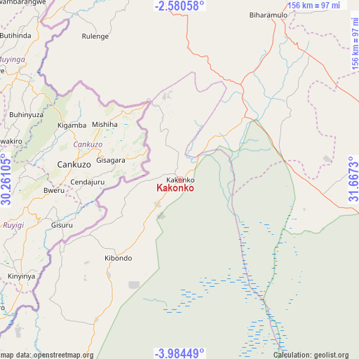
Kakonko GPS coordinates[2]
3° 16' 58.008" South, 30° 57' 51.012" East
| Map corner | latitude | longitude |
|---|---|---|
| Upper-left | -2.58058°, | 30.26105° |
| Center: | -3.28278°, | 30.96417° |
| Lower-right: | -3.98449°, | 31.6673° |
| Map W x H: | 156.1×156.1 km | = 97×97mi |
| max Lat: | -1.14389° ⇑18.2% North |
| Kakonko: | -3.28278° |
| min Lat: | ⇓81.8% South -11.36667° |
| min Long | Kakonko | max Long |
| 29.62667° | 30.96417° | 40.33333° |
| W 4.5%⇐ | ⇒95.5% E |
Elevation
Elevation of Kakonko is 1245 m = 4085 ft, and this is 302.2 m = 991 ft above average elevation for this country.
| Max E: |
2377 m = 7799 ft | 34.3% |
| Kakonko | 1245 m 4085 ft | |
| Avg. | 942.8 m = 3093 ft | |
Min E: |
0 m = 0 ft | 65.7% |
See also: Tanzania elevation on elevation.city.
Geographical zone
Kakonko is located in South Torrid zone (between Equator and Tropic of Capricorn). Distance of Equator is 365 km =226.8 mi to North.| Distance of | km | miles | from Kakonko |
|---|---|---|---|
| Equator | 365 | 226.8 | to North |
| Tropic Capricorn | 2240.9 | 1392.4 | to South |
| Antarctic Circle | 7036.2 | 4372.1 | to South |
| South Pole | 9642.1 | 5991.3 | to South |


Nearby cities:
15 places around Kakonko: (largest is in red/bold)
• Biharamulo
81.9 km =50.9 mi,  27°
27°
• Bugarama
66.7 km =41.4 mi,  313°
313°
• Buseresere
105.1 km =65.3 mi,  74°
74°
• Chato
114.4 km =71.1 mi,  51°
51°
• Geita
148 km =92 mi, 72°
• Kabanga
90.4 km =56.2 mi,  322°
322°
• Kasamwa
170.1 km =105.7 mi, 73°
• Katoro
107.5 km =66.8 mi, 74°
• Kibondo
43.3 km =26.9 mi,  218°
218°
• Mabamba
62.2 km =38.6 mi,  235°
235°
• Masumbwe
140.8 km =87.5 mi,  106°
106°
• Ngara
92.3 km =57.4 mi,  338°
338°
• Rulenge
72.8 km =45.2 mi,  329°
329°
• Ushirombo
113.4 km =70.5 mi,  101°
101°
• Uyovu
62.3 km =38.7 mi,  90°
90°
Sources, notices
• [Note1] Compared only with cities in Tanzania existing in our database
• [Src1] Map data: © OpenStreetMap contributors (CC-BY-SA)
• [Src2] Other city data from geonames.org with taken over terms of usage.
• [Src3] Geographical zone / Annual Mean Temperature by Robert A. Rohde @ Wikipedia
