Hayvoron geodata
Hayvoron (Kirovohrad) is a seat of a second-order administrative division; located in Ukraine in Europe/Kiev (GMT+3) time zone. With population of 15,526 people, there are 250 cities with bigger population in this country. Compared to other cities in Ukraine, 51.1% of cities are located further ↓South; 68.5% of cities are located further →East and 54.6% of cities have lower elevation than Hayvoron. Note1


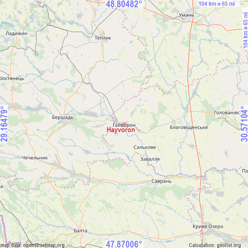
Hayvoron GPS coordinates[2]
48° 20' 22.488" North, 29° 52' 4.476" East
| Map corner | latitude | longitude |
|---|---|---|
| Upper-left | 48.80482°, | 29.16479° |
| Center: | 48.33958°, | 29.86791° |
| Lower-right: | 47.87006°, | 30.57104° |
| Map W x H: | 103.9×103.9 km | = 64.6×64.6mi |
| max Lat: | 52.18903° ⇑48.9% North |
| Hayvoron: | 48.33958° |
| min Lat: | ⇓51.1% South 44.39214° |
| min Long | Hayvoron | max Long |
| 22.20555° | 29.86791° | 40.13222° |
| W 31.5%⇐ | ⇒68.5% E |
Elevation
Elevation of Hayvoron is 151 m = 495 ft, and this is 4.8 m = 16 ft below average elevation for this country.
| Max E: |
886 m = 2907 ft | 45.4% |
| Avg. | 155.8 m = 511 ft | |
| Hayvoron | 151 m = 495 ft | |
Min E: |
-3 m = -10 ft | 54.6% |
See also: Ukraine elevation on elevation.city.
Geographical zone
Hayvoron is located in North temperate zone (between Tropic of Cancer and the Arctic Circle). Distance of this North polar circle is 2026.3 km =1259.1 mi to North.| Distance of | km | miles | from Hayvoron |
|---|---|---|---|
| North Pole | 4632.2 | 2878.3 | to North |
| Arctic Circle | 2026.3 | 1259.1 | to North |
| Tropic Cancer | 2768.9 | 1720.5 | to South |
| Equator | 5374.9 | 3339.8 | to South |


Nearby cities:
15 places around Hayvoron: (largest is in red/bold)
• Balta
48.6 km =30.2 mi,  202°
202°
• Bershad
26.1 km =16.2 mi,  276°
276°
• Blahovishchens’ke
26.6 km =16.5 mi,  92°
92°
• Chechelnyk
39.5 km =24.5 mi,  249°
249°
• Holovanivs’k
44.1 km =27.4 mi,  83°
83°
• Obodivka
46.4 km =28.8 mi, 279°
• Perehonivka
52.8 km =32.8 mi,  65°
65°
• Peschana
25.5 km =15.8 mi, 203°
• Savran
28 km =17.4 mi,  145°
145°
• Teplyk
37.4 km =23.2 mi,  345°
345°
• Torkanivka
53.3 km =33.1 mi,  268°
268°
• Trostyanets’
50.4 km =31.3 mi,  292°
292°
• Uman
52.4 km =32.6 mi,  29°
29°
• Viytivka
25.9 km =16.1 mi, 291°
• Zavallya
17.8 km =11.1 mi,  142°
142°
Sources, notices
• [Note1] Compared only with cities in Ukraine existing in our database
• [Src1] Map data: © OpenStreetMap contributors (CC-BY-SA)
• [Src2] Other city data from geonames.org with taken over terms of usage.
• [Src3] Geographical zone / Annual Mean Temperature by Robert A. Rohde @ Wikipedia
