Slavske geodata
Slavske (Lviv) is a populated place; located in Ukraine in Europe/Kiev (GMT+3) time zone. With population of 6,436 people, there are 542 cities with bigger population in this country. Compared to other cities in Ukraine, 62.9% of cities are located further ↓South; 96.2% of cities are located further →East and 99.1% of cities have lower elevation than Slavske. Note1


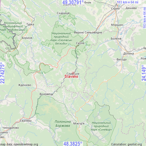
Slavske GPS coordinates[2]
48° 50' 50.424" North, 23° 26' 45.132" East
| Map corner | latitude | longitude |
|---|---|---|
| Upper-left | 49.30791°, | 22.74275° |
| Center: | 48.84734°, | 23.44587° |
| Lower-right: | 48.3825°, | 24.149° |
| Map W x H: | 102.9×102.9 km | = 63.9×63.9mi |
| max Lat: | 52.18903° ⇑37.1% North |
| Slavske: | 48.84734° |
| min Lat: | ⇓62.9% South 44.39214° |
| min Long | Slavske | max Long |
| 22.20555° | 23.44587° | 40.13222° |
| W 3.8%⇐ | ⇒96.2% E |
Elevation
Elevation of Slavske is 588 m = 1929 ft, and this is 432.2 m = 1418 ft above average elevation for this country.
| Max E: |
886 m = 2907 ft | 0.90000000000001% |
| Slavske | 588 m 1929 ft | |
| Avg. | 155.8 m = 511 ft | |
Min E: |
-3 m = -10 ft | 99.1% |
See also: Ukraine elevation on elevation.city.
Geographical zone
Slavske is located in North temperate zone (between Tropic of Cancer and the Arctic Circle). Distance of this North polar circle is 1969.9 km =1224 mi to North.| Distance of | km | miles | from Slavske |
|---|---|---|---|
| North Pole | 4575.7 | 2843.2 | to North |
| Arctic Circle | 1969.9 | 1224 | to North |
| Tropic Cancer | 2825.4 | 1755.6 | to South |
| Equator | 5431.3 | 3374.9 | to South |


Nearby cities:
15 places around Slavske: (largest is in red/bold)
• Bereznyky
40.6 km =25.2 mi,  204°
204°
• Bolekhiv
39.1 km =24.3 mi,  51°
51°
• Hrebeniv
13.4 km =8.3 mi,  11°
11°
• Lysychovo
40.6 km =25.2 mi, 196°
• Mizhhirya
36.2 km =22.5 mi,  173°
173°
• Pylypets
24.1 km =15 mi,  209°
209°
• Skhidnytsya
42.9 km =26.7 mi,  350°
350°
• Skole
21.7 km =13.5 mi, 13°
• Synevyr
42.1 km =26.2 mi,  161°
161°
• Synevyrska Poliana
34.2 km =21.3 mi,  148°
148°
• Tukhlia
7.5 km =4.7 mi,  15°
15°
• Verchnia Rozhanka
9 km =5.6 mi, 145°
• Verkhnie Synevydne
30.3 km =18.8 mi, 20°
• Volovets
24.4 km =15.2 mi,  231°
231°
• Розгирче
35.4 km =22 mi,  30°
30°
Sources, notices
• [Note1] Compared only with cities in Ukraine existing in our database
• [Src1] Map data: © OpenStreetMap contributors (CC-BY-SA)
• [Src2] Other city data from geonames.org with taken over terms of usage.
• [Src3] Geographical zone / Annual Mean Temperature by Robert A. Rohde @ Wikipedia
