Kryvyi Rih geodata
Kryvyi Rih (Dnipropetrovsk) is a seat of a second-order administrative division; located in Ukraine in Europe/Kiev (GMT+3) time zone. With population of 652,380 people, there are 7 cities with bigger population in this country. Compared to other cities in Ukraine, 57.7% of cities are located further ↑North; 50.7% of cities are located further ←West and 62.4% of cities have higher elevation than Kryvyi Rih. Note1


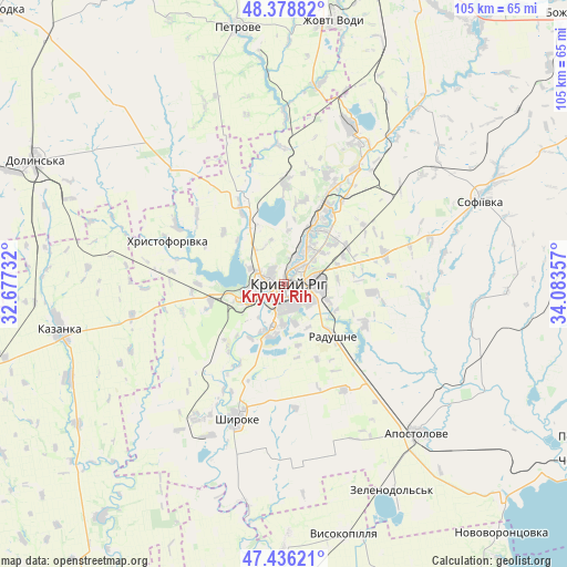
Kryvyi Rih GPS coordinates[2]
47° 54' 34.776" North, 33° 22' 49.584" East
| Map corner | latitude | longitude |
|---|---|---|
| Upper-left | 48.37882°, | 32.67732° |
| Center: | 47.90966°, | 33.38044° |
| Lower-right: | 47.43621°, | 34.08357° |
| Map W x H: | 104.8×104.8 km | = 65.1×65.1mi |
| max Lat: | 52.18903° ⇑57.7% North |
| Kryvyi Rih: | 47.90966° |
| min Lat: | ⇓42.3% South 44.39214° |
| min Long | Kryvyi Rih | max Long |
| 22.20555° | 33.38044° | 40.13222° |
| W 50.7%⇐ | ⇒49.3% E |
Elevation
Elevation of Kryvyi Rih is 99 m = 325 ft, and this is 56.8 m = 186 ft below average elevation for this country.
| Max E: |
886 m = 2907 ft | 62.4% |
| Avg. | 155.8 m = 511 ft | |
| Kryvyi Rih | 99 m = 325 ft | |
Min E: |
-3 m = -10 ft | 37.6% |
See also: Kryvyi Rih elevation on elevation.city.
Geographical zone
Kryvyi Rih is located in North temperate zone (between Tropic of Cancer and the Arctic Circle). Distance of this North polar circle is 2074.1 km =1288.8 mi to North.| Distance of | km | miles | from Kryvyi Rih |
|---|---|---|---|
| North Pole | 4680 | 2908 | to North |
| Arctic Circle | 2074.1 | 1288.8 | to North |
| Tropic Cancer | 2721.1 | 1690.8 | to South |
| Equator | 5327.1 | 3310.1 | to South |


Nearby cities:
15 places around Kryvyi Rih: (largest is in red/bold)
• Apostolove
37.3 km =23.2 mi,  138°
138°
• Dolyns'ka
51 km =31.7 mi,  295°
295°
• Kazanka
42.3 km =26.3 mi,  260°
260°
• Lozuvatka
17.8 km =11.1 mi,  336°
336°
• Molodizhne
61.3 km =38.1 mi, 299°
• Novovorontsovka
60.7 km =37.7 mi, 138°
• Ordzhonikidze
57.4 km =35.7 mi,  117°
117°
• Petrove
47.1 km =29.3 mi,  348°
348°
• Piatykhatky
61.1 km =38 mi,  23°
23°
• Sholokhove
54.2 km =33.7 mi, 116°
• Shyroke
25.9 km =16.1 mi,  200°
200°
• Sofiyivka
40 km =24.9 mi,  67°
67°
• Ustynivka
63.1 km =39.2 mi,  274°
274°
• Vysokopillya
47.8 km =29.7 mi,  166°
166°
• Zhovti Vody
49.3 km =30.6 mi,  10°
10°
In other languages:
- In Spanish: Kryvy Rig
- In France: Kryvyï Rih
- In German: Krywyj Rih
- In Italian: Kryvyj Rih
- In Russian: Кривой Рог
- In Chinese: 克雷维里格
Sources, notices
• [Note1] Compared only with cities in Ukraine existing in our database
• [Src1] Map data: © OpenStreetMap contributors (CC-BY-SA)
• [Src2] Other city data from geonames.org with taken over terms of usage.
• [Src3] Geographical zone / Annual Mean Temperature by Robert A. Rohde @ Wikipedia
