Druzhba geodata
Druzhba (Chernihiv) is a populated place; located in Ukraine in Europe/Kiev (GMT+3) time zone. With population of 793 people, there are 1487 cities with bigger population in this country. Compared to other cities in Ukraine, 94.2% of cities are located further ↓South; 56% of cities are located further →East and 58.3% of cities have lower elevation than Druzhba. Note1


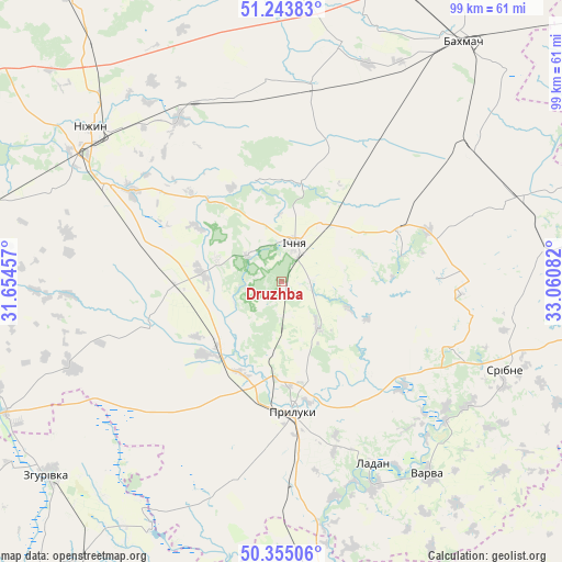
Druzhba GPS coordinates[2]
50° 48' 5.616" North, 32° 21' 27.684" East
| Map corner | latitude | longitude |
|---|---|---|
| Upper-left | 51.24383°, | 31.65457° |
| Center: | 50.80156°, | 32.35769° |
| Lower-right: | 50.35506°, | 33.06082° |
| Map W x H: | 98.8×98.8 km | = 61.4×61.4mi |
| max Lat: | 52.18903° ⇑5.8% North |
| Druzhba: | 50.80156° |
| min Lat: | ⇓94.2% South 44.39214° |
| min Long | Druzhba | max Long |
| 22.20555° | 32.35769° | 40.13222° |
| W 44%⇐ | ⇒56% E |
Elevation
Elevation of Druzhba is 162 m = 531 ft, and this is 6.2 m = 20 ft above average elevation for this country.
| Max E: |
886 m = 2907 ft | 41.7% |
| Druzhba | 162 m 531 ft | |
| Avg. | 155.8 m = 511 ft | |
Min E: |
-3 m = -10 ft | 58.3% |
See also: Ukraine elevation on elevation.city.
Geographical zone
Druzhba is located in North temperate zone (between Tropic of Cancer and the Arctic Circle). Distance of this North polar circle is 1752.6 km =1089 mi to North.| Distance of | km | miles | from Druzhba |
|---|---|---|---|
| North Pole | 4358.5 | 2708.2 | to North |
| Arctic Circle | 1752.6 | 1089 | to North |
| Tropic Cancer | 3042.7 | 1890.6 | to South |
| Equator | 5648.6 | 3509.9 | to South |


Nearby cities:
15 places around Druzhba: (largest is in red/bold)
• Bakhmach
53.1 km =33 mi,  33°
33°
• Borzna
50.6 km =31.4 mi,  5°
5°
• Dihtyari
37.9 km =23.5 mi,  129°
129°
• Ichnya
7.3 km =4.5 mi,  20°
20°
• Kruty
33.7 km =20.9 mi,  328°
328°
• Kunashëvka
35.9 km =22.3 mi,  317°
317°
• Ladan
35.1 km =21.8 mi,  153°
153°
• Lisovi Sorochyntsi
12.7 km =7.9 mi,  189°
189°
• Nizhyn
42.9 km =26.7 mi,  309°
309°
• Pryluky
23.3 km =14.5 mi,  174°
174°
• Sribne
42.3 km =26.3 mi,  111°
111°
• Talalayivka
35.2 km =21.9 mi,  299°
299°
• Varva
42.6 km =26.5 mi,  143°
143°
• Zgurovka
52.3 km =32.5 mi,  230°
230°
• Zhuravka
39.4 km =24.5 mi, 154°
Sources, notices
• [Note1] Compared only with cities in Ukraine existing in our database
• [Src1] Map data: © OpenStreetMap contributors (CC-BY-SA)
• [Src2] Other city data from geonames.org with taken over terms of usage.
• [Src3] Geographical zone / Annual Mean Temperature by Robert A. Rohde @ Wikipedia
