Talalayivka geodata
Talalayivka (Chernihiv) is a populated place; located in Ukraine in Europe/Kiev (GMT+3) time zone. With population of 5,054 people, there are 646 cities with bigger population in this country. Compared to other cities in Ukraine, 95.5% of cities are located further ↓South; 57.6% of cities are located further →East and 51.8% of cities have higher elevation than Talalayivka. Note1


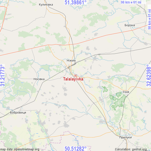
Talalayivka GPS coordinates[2]
50° 57' 28.188" North, 31° 55' 15.06" East
| Map corner | latitude | longitude |
|---|---|---|
| Upper-left | 51.39861°, | 31.21773° |
| Center: | 50.95783°, | 31.92085° |
| Lower-right: | 50.51282°, | 32.62398° |
| Map W x H: | 98.5×98.5 km | = 61.2×61.2mi |
| max Lat: | 52.18903° ⇑4.5% North |
| Talalayivka: | 50.95783° |
| min Lat: | ⇓95.5% South 44.39214° |
| min Long | Talalayivka | max Long |
| 22.20555° | 31.92085° | 40.13222° |
| W 42.4%⇐ | ⇒57.6% E |
Elevation
Elevation of Talalayivka is 128 m = 420 ft, and this is 27.8 m = 91 ft below average elevation for this country.
| Max E: |
886 m = 2907 ft | 51.8% |
| Avg. | 155.8 m = 511 ft | |
| Talalayivka | 128 m = 420 ft | |
Min E: |
-3 m = -10 ft | 48.2% |
See also: Ukraine elevation on elevation.city.
Geographical zone
Talalayivka is located in North temperate zone (between Tropic of Cancer and the Arctic Circle). Distance of this North polar circle is 1735.2 km =1078.2 mi to North.| Distance of | km | miles | from Talalayivka |
|---|---|---|---|
| North Pole | 4341.1 | 2697.4 | to North |
| Arctic Circle | 1735.2 | 1078.2 | to North |
| Tropic Cancer | 3060.1 | 1901.5 | to South |
| Equator | 5666 | 3520.7 | to South |


Nearby cities:
15 places around Talalayivka: (largest is in red/bold)
• Bobrovytsya
43.7 km =27.2 mi,  237°
237°
• Borzna
48.3 km =30 mi,  46°
46°
• Druzhba
35.2 km =21.9 mi,  119°
119°
• Ichnya
34.8 km =21.6 mi,  107°
107°
• Kobyzhcha
32.6 km =20.3 mi, 243°
• Kozelets’
56.2 km =34.9 mi,  264°
264°
• Kruty
17.2 km =10.7 mi, 48°
• Kulykivka
50 km =31.1 mi,  337°
337°
• Kunashëvka
11.3 km =7 mi,  34°
34°
• Lisovi Sorochyntsi
41.4 km =25.7 mi,  136°
136°
• Nizhyn
10.3 km =6.4 mi,  346°
346°
• Nosivka
23.9 km =14.9 mi, 262°
• Olyshivka
50.5 km =31.4 mi,  305°
305°
• Pryluky
52.2 km =32.4 mi, 141°
• Zgurovka
51.5 km =32 mi,  190°
190°
Sources, notices
• [Note1] Compared only with cities in Ukraine existing in our database
• [Src1] Map data: © OpenStreetMap contributors (CC-BY-SA)
• [Src2] Other city data from geonames.org with taken over terms of usage.
• [Src3] Geographical zone / Annual Mean Temperature by Robert A. Rohde @ Wikipedia
