Ichnya geodata
Ichnya (Chernihiv) is a seat of a second-order administrative division; located in Ukraine in Europe/Kiev (GMT+3) time zone. With population of 12,417 people, there are 301 cities with bigger population in this country. Compared to other cities in Ukraine, 94.9% of cities are located further ↓South; 55.8% of cities are located further →East and 56% of cities have lower elevation than Ichnya. Note1


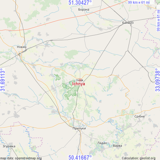
Ichnya GPS coordinates[2]
50° 51' 45.288" North, 32° 23' 39.3" East
| Map corner | latitude | longitude |
|---|---|---|
| Upper-left | 51.30427°, | 31.69113° |
| Center: | 50.86258°, | 32.39425° |
| Lower-right: | 50.41667°, | 33.09738° |
| Map W x H: | 98.7×98.7 km | = 61.3×61.3mi |
| max Lat: | 52.18903° ⇑5.1% North |
| Ichnya: | 50.86258° |
| min Lat: | ⇓94.9% South 44.39214° |
| min Long | Ichnya | max Long |
| 22.20555° | 32.39425° | 40.13222° |
| W 44.2%⇐ | ⇒55.8% E |
Elevation
Elevation of Ichnya is 155 m = 509 ft, and this is 0.80000000000001 m = 3 ft below average elevation for this country.
| Max E: |
886 m = 2907 ft | 44% |
| Avg. | 155.8 m = 511 ft | |
| Ichnya | 155 m = 509 ft | |
Min E: |
-3 m = -10 ft | 56% |
See also: Ukraine elevation on elevation.city.
Geographical zone
Ichnya is located in North temperate zone (between Tropic of Cancer and the Arctic Circle). Distance of this North polar circle is 1745.8 km =1084.8 mi to North.| Distance of | km | miles | from Ichnya |
|---|---|---|---|
| North Pole | 4351.7 | 2704 | to North |
| Arctic Circle | 1745.8 | 1084.8 | to North |
| Tropic Cancer | 3049.5 | 1894.9 | to South |
| Equator | 5655.4 | 3514.1 | to South |


Nearby cities:
15 places around Ichnya: (largest is in red/bold)
• Bakhmach
46.1 km =28.6 mi,  35°
35°
• Bakhmach
47 km =29.2 mi, 40°
• Borzna
43.7 km =27.2 mi,  2°
2°
• Dihtyari
40.9 km =25.4 mi,  139°
139°
• Druzhba
7.3 km =4.5 mi,  200°
200°
• Kruty
29.8 km =18.5 mi,  317°
317°
• Kunashëvka
33.2 km =20.6 mi,  306°
306°
• Ladan
40.4 km =25.1 mi,  160°
160°
• Lisovi Sorochyntsi
19.8 km =12.3 mi,  193°
193°
• Nizhyn
41.1 km =25.5 mi,  300°
300°
• Pryluky
30 km =18.6 mi,  180°
180°
• Sribne
43 km =26.7 mi,  120°
120°
• Talalayivka
34.8 km =21.6 mi,  287°
287°
• Varva
46.9 km =29.1 mi,  150°
150°
• Zhuravka
44.7 km =27.8 mi, 161°
Sources, notices
• [Note1] Compared only with cities in Ukraine existing in our database
• [Src1] Map data: © OpenStreetMap contributors (CC-BY-SA)
• [Src2] Other city data from geonames.org with taken over terms of usage.
• [Src3] Geographical zone / Annual Mean Temperature by Robert A. Rohde @ Wikipedia
