Kodyma geodata
Kodyma (Odesa) is a seat of a second-order administrative division; located in Ukraine in Europe/Kiev (GMT+3) time zone. With population of 9,276 people, there are 391 cities with bigger population in this country. Compared to other cities in Ukraine, 54.8% of cities are located further ↑North; 72.1% of cities are located further →East and 87.3% of cities have lower elevation than Kodyma. Note1


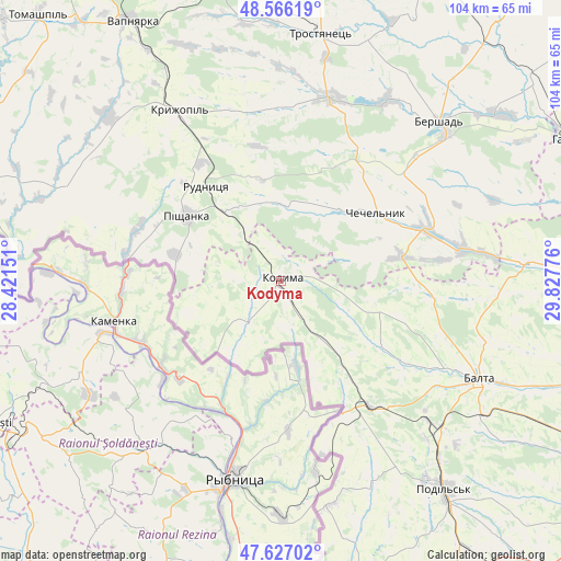
Kodyma GPS coordinates[2]
48° 5' 55.5" North, 29° 7' 28.668" East
| Map corner | latitude | longitude |
|---|---|---|
| Upper-left | 48.56619°, | 28.42151° |
| Center: | 48.09875°, | 29.12463° |
| Lower-right: | 47.62702°, | 29.82776° |
| Map W x H: | 104.4×104.4 km | = 64.9×64.9mi |
| max Lat: | 52.18903° ⇑54.8% North |
| Kodyma: | 48.09875° |
| min Lat: | ⇓45.2% South 44.39214° |
| min Long | Kodyma | max Long |
| 22.20555° | 29.12463° | 40.13222° |
| W 27.9%⇐ | ⇒72.1% E |
Elevation
Elevation of Kodyma is 289 m = 948 ft, and this is 133.2 m = 437 ft above average elevation for this country.
| Max E: |
886 m = 2907 ft | 12.7% |
| Kodyma | 289 m 948 ft | |
| Avg. | 155.8 m = 511 ft | |
Min E: |
-3 m = -10 ft | 87.3% |
See also: Ukraine elevation on elevation.city.
Geographical zone
Kodyma is located in North temperate zone (between Tropic of Cancer and the Arctic Circle). Distance of this North polar circle is 2053.1 km =1275.7 mi to North.| Distance of | km | miles | from Kodyma |
|---|---|---|---|
| North Pole | 4659 | 2895 | to North |
| Arctic Circle | 2053.1 | 1275.7 | to North |
| Tropic Cancer | 2742.2 | 1703.9 | to South |
| Equator | 5348.1 | 3323.2 | to South |


Nearby cities:
15 places around Kodyma: (largest is in red/bold)
• Balta
41.1 km =25.5 mi,  116°
116°
• Bershad
41.7 km =25.9 mi,  44°
44°
• Chechelnyk
22.2 km =13.8 mi,  54°
54°
• Kryzhopil’
36.9 km =22.9 mi,  328°
328°
• Obodivka
35.3 km =21.9 mi,  14°
14°
• Peschana
45.1 km =28 mi,  85°
85°
• Pishchanka
21.4 km =13.3 mi,  304°
304°
• Podil’s’k
49 km =30.4 mi,  141°
141°
• Slobidka
28.7 km =17.8 mi,  145°
145°
• Torkanivka
25.2 km =15.7 mi,  3°
3°
• Trostyanets’
46.4 km =28.8 mi, 10°
• Tsybulevka
32.1 km =19.9 mi,  357°
357°
• Vapnyarka
56.1 km =34.9 mi, 329°
• Viytivka
47.8 km =29.7 mi, 40°
• Zagnitkiv
18.1 km =11.2 mi,  252°
252°
Sources, notices
• [Note1] Compared only with cities in Ukraine existing in our database
• [Src1] Map data: © OpenStreetMap contributors (CC-BY-SA)
• [Src2] Other city data from geonames.org with taken over terms of usage.
• [Src3] Geographical zone / Annual Mean Temperature by Robert A. Rohde @ Wikipedia
