Chechelnyk geodata
Chechelnyk (Vinnyts'ka) is a seat of a second-order administrative division; located in Ukraine in Europe/Kiev (GMT+3) time zone. With population of 5,100 people, there are 642 cities with bigger population in this country. Compared to other cities in Ukraine, 51.9% of cities are located further ↑North; 70.8% of cities are located further →East and 59.7% of cities have lower elevation than Chechelnyk. Note1


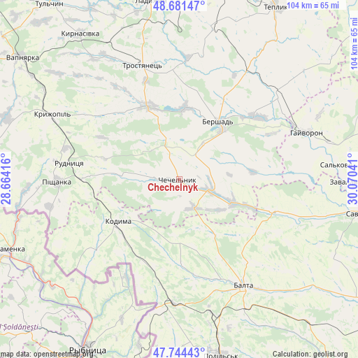
Chechelnyk GPS coordinates[2]
48° 12' 54.324" North, 29° 22' 2.208" East
| Map corner | latitude | longitude |
|---|---|---|
| Upper-left | 48.68147°, | 28.66416° |
| Center: | 48.21509°, | 29.36728° |
| Lower-right: | 47.74443°, | 30.07041° |
| Map W x H: | 104.2×104.2 km | = 64.7×64.7mi |
| max Lat: | 52.18903° ⇑51.9% North |
| Chechelnyk: | 48.21509° |
| min Lat: | ⇓48.1% South 44.39214° |
| min Long | Chechelnyk | max Long |
| 22.20555° | 29.36728° | 40.13222° |
| W 29.2%⇐ | ⇒70.8% E |
Elevation
Elevation of Chechelnyk is 168 m = 551 ft, and this is 12.2 m = 40 ft above average elevation for this country.
| Max E: |
886 m = 2907 ft | 40.3% |
| Chechelnyk | 168 m 551 ft | |
| Avg. | 155.8 m = 511 ft | |
Min E: |
-3 m = -10 ft | 59.7% |
See also: Ukraine elevation on elevation.city.
Geographical zone
Chechelnyk is located in North temperate zone (between Tropic of Cancer and the Arctic Circle). Distance of this North polar circle is 2040.2 km =1267.7 mi to North.| Distance of | km | miles | from Chechelnyk |
|---|---|---|---|
| North Pole | 4646 | 2886.9 | to North |
| Arctic Circle | 2040.2 | 1267.7 | to North |
| Tropic Cancer | 2755.1 | 1711.9 | to South |
| Equator | 5361 | 3331.2 | to South |


Nearby cities:
15 places around Chechelnyk: (largest is in red/bold)
• Balta
36.3 km =22.6 mi,  148°
148°
• Bershad
20.3 km =12.6 mi,  33°
33°
• Hayvoron
39.5 km =24.5 mi,  69°
69°
• Kodyma
22.2 km =13.8 mi,  234°
234°
• Kryzhopil’
41.5 km =25.8 mi,  296°
296°
• Obodivka
22.9 km =14.2 mi,  337°
337°
• Peschana
28.6 km =17.8 mi,  109°
109°
• Pishchanka
35.7 km =22.2 mi,  268°
268°
• Slobidka
36.5 km =22.7 mi,  182°
182°
• Torkanivka
20.3 km =12.6 mi,  306°
306°
• Trostyanets’
34.2 km =21.3 mi, 343°
• Tsybulevka
27.4 km =17 mi, 314°
• Viytivka
26.8 km =16.7 mi, 28°
• Zagnitkiv
39.8 km =24.7 mi,  242°
242°
• Zavallya
48 km =29.8 mi,  90°
90°
Sources, notices
• [Note1] Compared only with cities in Ukraine existing in our database
• [Src1] Map data: © OpenStreetMap contributors (CC-BY-SA)
• [Src2] Other city data from geonames.org with taken over terms of usage.
• [Src3] Geographical zone / Annual Mean Temperature by Robert A. Rohde @ Wikipedia
