Paidha geodata
Paidha (Northern Region) is a populated place; located in Uganda in Africa/Kampala (GMT+3) time zone. With population of 28,348 people, there are 29 cities with bigger population in this country. Compared to other cities in Uganda, 85.6% of cities are located further ↓South; 76% of cities are located further →East and 87% of cities have lower elevation than Paidha. Note1
Administrative division(s):
- Level 1: Northern Region
- Level 2: Zombo District
- Level 3: Okoro County
- Level 4: Paidha Town Council


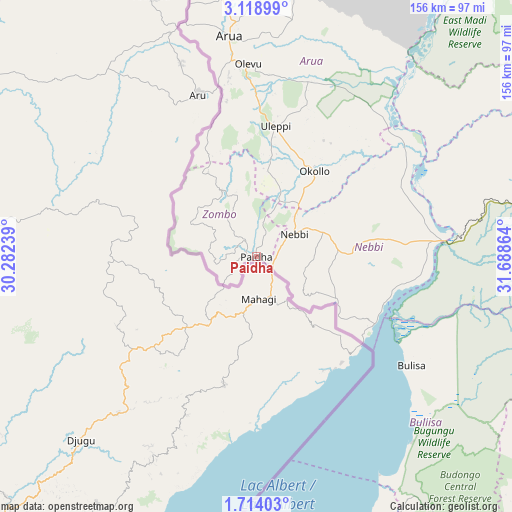
Paidha GPS coordinates[2]
2° 25' 0.084" North, 30° 59' 7.836" East
| Map corner | latitude | longitude |
|---|---|---|
| Upper-left | 3.11899°, | 30.28239° |
| Center: | 2.41669°, | 30.98551° |
| Lower-right: | 1.71403°, | 31.68864° |
| Map W x H: | 156.2×156.2 km | = 97.1×97.1mi |
| max Lat: | 3.66088° ⇑14.4% North |
| Paidha: | 2.41669° |
| min Lat: | ⇓85.6% South -1.28538° |
| min Long | Paidha | max Long |
| 29.65° | 30.98551° | 34.95° |
| W 24%⇐ | ⇒76% E |
Elevation
Elevation of Paidha is 1496 m = 4908 ft, and this is 237 m = 778 ft above average elevation for this country.
| Max E: |
4129 m = 13547 ft | 13% |
| Paidha | 1496 m 4908 ft | |
| Avg. | 1259 m = 4131 ft | |
Min E: |
622 m = 2041 ft | 87% |
See also: Uganda elevation on elevation.city.
Geographical zone
Paidha is located in North Torrid zone (between Equator and Tropic of Cancer). Distance of Equator is 268.7 km =167 mi to South.| Distance of | km | miles | from Paidha |
|---|---|---|---|
| North Pole | 9738.4 | 6051.2 | to North |
| Arctic Circle | 7132.5 | 4431.9 | to North |
| Tropic Cancer | 2337.2 | 1452.3 | to North |
| Equator | 268.7 | 167 | to South |


Nearby cities:
15 places around Paidha: (largest is in red/bold)
• Adjumani
139.4 km =86.6 mi,  39°
39°
• Amuru
114.7 km =71.3 mi,  67°
67°
• Arua
67.6 km =42 mi,  352°
352°
• Bulisa
57.8 km =35.9 mi,  125°
125°
• Hoima
116.7 km =72.5 mi,  159°
159°
• Kigorobya
96 km =59.7 mi, 158°
• Kiryandongo
133.9 km =83.2 mi,  116°
116°
• Koboko
110.9 km =68.9 mi,  358°
358°
• Maracha
95 km =59 mi, 357°
• Masindi
115.7 km =71.9 mi,  135°
135°
• Masindi Port
146.2 km =90.8 mi, 123°
• Nebbi
13.4 km =8.3 mi,  59°
59°
• Nwoya
115.4 km =71.7 mi,  77°
77°
• Yumbe
120.1 km =74.6 mi,  13°
13°
• Zombo
13.7 km =8.5 mi,  321°
321°
Sources, notices
• [Note1] Compared only with cities in Uganda existing in our database
• [Src1] Map data: © OpenStreetMap contributors (CC-BY-SA)
• [Src2] Other city data from geonames.org with taken over terms of usage.
• [Src3] Geographical zone / Annual Mean Temperature by Robert A. Rohde @ Wikipedia
