Adjumani geodata
Adjumani (Northern Region) is a seat of a second-order administrative division; located in Uganda in Africa/Kampala (GMT+3) time zone. With population of 28,700 people, there are 28 cities with bigger population in this country. Compared to other cities in Uganda, 96.6% of cities are located further ↓South; 60.3% of cities are located further →East and 98.6% of cities have higher elevation than Adjumani. Note1
Administrative division(s):
- Level 1: Northern Region
- Level 2: Adjumani District
- Level 3: East Moyo
- Level 4: Adjumani Town Council


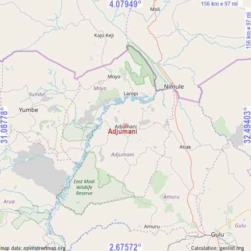
Adjumani GPS coordinates[2]
3° 22' 40.296" North, 31° 47' 27.24" East
| Map corner | latitude | longitude |
|---|---|---|
| Upper-left | 4.07949°, | 31.08778° |
| Center: | 3.37786°, | 31.7909° |
| Lower-right: | 2.67572°, | 32.49403° |
| Map W x H: | 156.1×156.1 km | = 97×97mi |
| max Lat: | 3.66088° ⇑3.4% North |
| Adjumani: | 3.37786° |
| min Lat: | ⇓96.6% South -1.28538° |
| min Long | Adjumani | max Long |
| 29.65° | 31.7909° | 34.95° |
| W 39.7%⇐ | ⇒60.3% E |
Elevation
Elevation of Adjumani is 816 m = 2677 ft, and this is 443 m = 1453 ft below average elevation for this country.
| Max E: |
4129 m = 13547 ft | 98.6% |
| Avg. | 1259 m = 4131 ft | |
| Adjumani | 816 m = 2677 ft | |
Min E: |
622 m = 2041 ft | 1.4% |
See also: Uganda elevation on elevation.city.
Geographical zone
Adjumani is located in North Torrid zone (between Equator and Tropic of Cancer). Distance of Equator is 375.6 km =233.4 mi to South.| Distance of | km | miles | from Adjumani |
|---|---|---|---|
| North Pole | 9631.5 | 5984.7 | to North |
| Arctic Circle | 7025.6 | 4365.5 | to North |
| Tropic Cancer | 2230.3 | 1385.8 | to North |
| Equator | 375.6 | 233.4 | to South |


Nearby cities:
15 places around Adjumani: (largest is in red/bold)
• Amuru
64.8 km =40.3 mi,  165°
165°
• Arua
105.5 km =65.6 mi,  247°
247°
• Bulisa
146.3 km =90.9 mi,  196°
196°
• Gulu
87.6 km =54.4 mi,  139°
139°
• Kitgum
122.1 km =75.9 mi,  95°
95°
• Koboko
92.3 km =57.4 mi,  272°
272°
• Lamwo
113.4 km =70.5 mi,  81°
81°
• Maracha
93.5 km =58.1 mi,  262°
262°
• Moyo
32.3 km =20.1 mi,  346°
346°
• Nebbi
126.8 km =78.8 mi,  217°
217°
• Nwoya
85.9 km =53.4 mi,  164°
164°
• Oyam
143.2 km =89 mi,  152°
152°
• Paidha
139.4 km =86.6 mi, 219°
• Yumbe
61.2 km =38 mi,  279°
279°
• Zombo
137.2 km =85.3 mi,  225°
225°
Sources, notices
• [Note1] Compared only with cities in Uganda existing in our database
• [Src1] Map data: © OpenStreetMap contributors (CC-BY-SA)
• [Src2] Other city data from geonames.org with taken over terms of usage.
• [Src3] Geographical zone / Annual Mean Temperature by Robert A. Rohde @ Wikipedia
