Arua geodata
Arua (Northern Region) is a seat of a second-order administrative division; located in Uganda in Africa/Kampala (GMT+3) time zone. With population of 55,585 people, there are 14 cities with bigger population in this country. Compared to other cities in Uganda, 93.8% of cities are located further ↓South; 78.1% of cities are located further →East and 57.5% of cities have lower elevation than Arua. Note1
Administrative division(s):
- Level 1: Northern Region
- Level 2: Arua District
- Level 3: Arua Municipality
- Level 4: Arua Hill Division


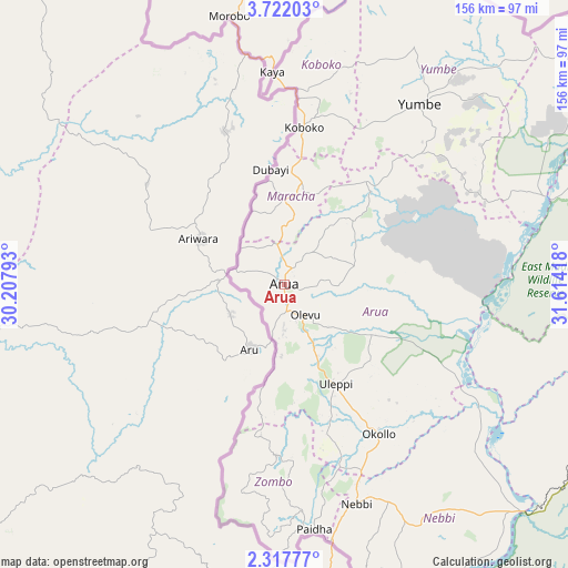
Arua GPS coordinates[2]
3° 1' 12.468" North, 30° 54' 39.78" East
| Map corner | latitude | longitude |
|---|---|---|
| Upper-left | 3.72203°, | 30.20793° |
| Center: | 3.02013°, | 30.91105° |
| Lower-right: | 2.31777°, | 31.61418° |
| Map W x H: | 156.1×156.1 km | = 97×97mi |
| max Lat: | 3.66088° ⇑6.2% North |
| Arua: | 3.02013° |
| min Lat: | ⇓93.8% South -1.28538° |
| min Long | Arua | max Long |
| 29.65° | 30.91105° | 34.95° |
| W 21.9%⇐ | ⇒78.1% E |
Elevation
Elevation of Arua is 1215 m = 3986 ft, and this is 44 m = 144 ft below average elevation for this country.
| Max E: |
4129 m = 13547 ft | 42.5% |
| Avg. | 1259 m = 4131 ft | |
| Arua | 1215 m = 3986 ft | |
Min E: |
622 m = 2041 ft | 57.5% |
See also: Arua elevation on elevation.city.
Geographical zone
Arua is located in North Torrid zone (between Equator and Tropic of Cancer). Distance of Equator is 335.8 km =208.7 mi to South.| Distance of | km | miles | from Arua |
|---|---|---|---|
| North Pole | 9671.3 | 6009.5 | to North |
| Arctic Circle | 7065.4 | 4390.2 | to North |
| Tropic Cancer | 2270.1 | 1410.6 | to North |
| Equator | 335.8 | 208.7 | to South |


Nearby cities:
15 places around Arua: (largest is in red/bold)
• Adjumani
105.5 km =65.6 mi,  67°
67°
• Amuru
116.4 km =72.3 mi,  101°
101°
• Bulisa
114.7 km =71.3 mi,  151°
151°
• Gulu
156.5 km =97.2 mi, 100°
• Kigorobya
162.2 km =100.8 mi,  164°
164°
• Kiryandongo
180.4 km =112.1 mi,  134°
134°
• Koboko
44.1 km =27.4 mi,  7°
7°
• Maracha
28.3 km =17.6 mi, 10°
• Masindi
174.3 km =108.3 mi, 149°
• Moyo
115 km =71.5 mi,  51°
51°
• Nebbi
63.4 km =39.4 mi, 161°
• Nwoya
128.4 km =79.8 mi,  109°
109°
• Paidha
67.6 km =42 mi,  172°
172°
• Yumbe
61.9 km =38.5 mi,  37°
37°
• Zombo
56.3 km =35 mi,  180°
180°
Sources, notices
• [Note1] Compared only with cities in Uganda existing in our database
• [Src1] Map data: © OpenStreetMap contributors (CC-BY-SA)
• [Src2] Other city data from geonames.org with taken over terms of usage.
• [Src3] Geographical zone / Annual Mean Temperature by Robert A. Rohde @ Wikipedia
