Maracha geodata
Maracha (Northern Region) is a seat of a second-order administrative division; located in Uganda in Africa/Kampala (GMT+3) time zone. In our database, there are 80 cities with bigger population. Compared to other cities in Uganda, 95.2% of cities are located further ↓South; 77.4% of cities are located further →East and 51.4% of cities have higher elevation than Maracha. Note1
Administrative division(s):
- Level 1: Northern Region
- Level 2: Maracha District
- Level 3: Maracha County
- Level 4: Maracha Town Council


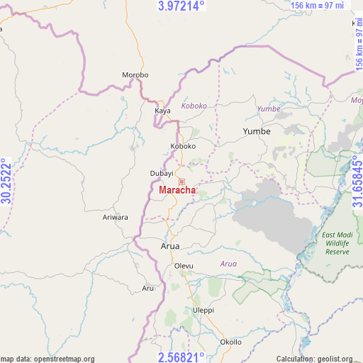
Maracha GPS coordinates[2]
3° 16' 13.512" North, 30° 57' 19.152" East
| Map corner | latitude | longitude |
|---|---|---|
| Upper-left | 3.97214°, | 30.2522° |
| Center: | 3.27042°, | 30.95532° |
| Lower-right: | 2.56821°, | 31.65845° |
| Map W x H: | 156.1×156.1 km | = 97×97mi |
| max Lat: | 3.66088° ⇑4.8% North |
| Maracha: | 3.27042° |
| min Lat: | ⇓95.2% South -1.28538° |
| min Long | Maracha | max Long |
| 29.65° | 30.95532° | 34.95° |
| W 22.6%⇐ | ⇒77.4% E |
Elevation
Elevation of Maracha is 1182 m = 3878 ft, and this is 77 m = 253 ft below average elevation for this country.
| Max E: |
4129 m = 13547 ft | 51.4% |
| Avg. | 1259 m = 4131 ft | |
| Maracha | 1182 m = 3878 ft | |
Min E: |
622 m = 2041 ft | 48.6% |
See also: Uganda elevation on elevation.city.
Geographical zone
Maracha is located in North Torrid zone (between Equator and Tropic of Cancer). Distance of Equator is 363.6 km =225.9 mi to South.| Distance of | km | miles | from Maracha |
|---|---|---|---|
| North Pole | 9643.4 | 5992.1 | to North |
| Arctic Circle | 7037.5 | 4372.9 | to North |
| Tropic Cancer | 2242.3 | 1393.3 | to North |
| Equator | 363.6 | 225.9 | to South |


Nearby cities:
15 places around Maracha: (largest is in red/bold)
• Adjumani
93.5 km =58.1 mi,  82°
82°
• Amuru
120.4 km =74.8 mi,  114°
114°
• Arua
28.3 km =17.6 mi,  190°
190°
• Bulisa
137.8 km =85.6 mi,  158°
158°
• Gulu
159.1 km =98.9 mi, 110°
• Kigorobya
188.1 km =116.9 mi,  167°
167°
• Koboko
15.9 km =9.9 mi,  1°
1°
• Masindi
196.5 km =122.1 mi,  154°
154°
• Moyo
95.8 km =59.5 mi,  63°
63°
• Nebbi
89.3 km =55.5 mi, 170°
• Nwoya
136 km =84.5 mi,  121°
121°
• Oyam
196.1 km =121.9 mi,  125°
125°
• Paidha
95 km =59 mi,  177°
177°
• Yumbe
38.9 km =24.2 mi, 56°
• Zombo
84.3 km =52.4 mi, 183°
Sources, notices
• [Note1] Compared only with cities in Uganda existing in our database
• [Src1] Map data: © OpenStreetMap contributors (CC-BY-SA)
• [Src2] Other city data from geonames.org with taken over terms of usage.
• [Src3] Geographical zone / Annual Mean Temperature by Robert A. Rohde @ Wikipedia
