Kiryandongo geodata
Kiryandongo (Western Region) is a seat of a second-order administrative division; located in Uganda in Africa/Kampala (GMT+3) time zone. In our database, there are 80 cities with bigger population. Compared to other cities in Uganda, 76.7% of cities are located further ↓South; 56.2% of cities are located further →East and 80.1% of cities have higher elevation than Kiryandongo. Note1
Administrative division(s):
- Level 1: Western Region
- Level 2: Kiryandongo District
- Level 3: Kibanda
- Level 4: Kiryandongo Town Council


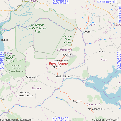
Kiryandongo GPS coordinates[2]
1° 52' 34.788" North, 32° 3' 44.1" East
| Map corner | latitude | longitude |
|---|---|---|
| Upper-left | 2.57892°, | 31.35913° |
| Center: | 1.87633°, | 32.06225° |
| Lower-right: | 1.17346°, | 32.76538° |
| Map W x H: | 156.3×156.3 km | = 97.1×97.1mi |
| max Lat: | 3.66088° ⇑23.3% North |
| Kiryandongo: | 1.87633° |
| min Lat: | ⇓76.7% South -1.28538° |
| min Long | Kiryandongo | max Long |
| 29.65° | 32.06225° | 34.95° |
| W 43.8%⇐ | ⇒56.2% E |
Elevation
Elevation of Kiryandongo is 1086 m = 3563 ft, and this is 173 m = 568 ft below average elevation for this country.
| Max E: |
4129 m = 13547 ft | 80.1% |
| Avg. | 1259 m = 4131 ft | |
| Kiryandongo | 1086 m = 3563 ft | |
Min E: |
622 m = 2041 ft | 19.9% |
See also: Uganda elevation on elevation.city.
Geographical zone
Kiryandongo is located in North Torrid zone (between Equator and Tropic of Cancer). Distance of Equator is 208.6 km =129.6 mi to South.| Distance of | km | miles | from Kiryandongo |
|---|---|---|---|
| North Pole | 9798.4 | 6088.4 | to North |
| Arctic Circle | 7192.5 | 4469.2 | to North |
| Tropic Cancer | 2397.3 | 1489.6 | to North |
| Equator | 208.6 | 129.6 | to South |


Nearby cities:
15 places around Kiryandongo: (largest is in red/bold)
• Amolatar
91.1 km =56.6 mi,  108°
108°
• Amuru
105.1 km =65.3 mi,  352°
352°
• Apac
54.1 km =33.6 mi,  78°
78°
• Bulisa
77.1 km =47.9 mi,  290°
290°
• Gulu
103.3 km =64.2 mi,  14°
14°
• Hoima
93 km =57.8 mi,  238°
238°
• Kigorobya
88.6 km =55.1 mi,  250°
250°
• Kole
100.6 km =62.5 mi,  54°
54°
• Kyankwanzi
80.6 km =50.1 mi,  201°
201°
• Lira
101.9 km =63.3 mi,  65°
65°
• Masindi
44.6 km =27.7 mi, 239°
• Masindi Port
20.2 km =12.6 mi,  172°
172°
• Nakasongola
76.8 km =47.7 mi,  145°
145°
• Nwoya
84.5 km =52.5 mi,  355°
355°
• Oyam
53.6 km =33.3 mi,  41°
41°
Sources, notices
• [Note1] Compared only with cities in Uganda existing in our database
• [Src1] Map data: © OpenStreetMap contributors (CC-BY-SA)
• [Src2] Other city data from geonames.org with taken over terms of usage.
• [Src3] Geographical zone / Annual Mean Temperature by Robert A. Rohde @ Wikipedia
