Masindi Port geodata
Masindi Port (Western Region) is a populated place; located in Uganda in Africa/Kampala (GMT+3) time zone. With population of 7,828 people, there are 68 cities with bigger population in this country. Compared to other cities in Uganda, 74.7% of cities are located further ↓South; 55.5% of cities are located further →East and 91.1% of cities have higher elevation than Masindi Port. Note1
Administrative division(s):
- Level 1: Western Region
- Level 2: Kiryandongo District
- Level 3: Kibanda
- Level 4: Masindi Port


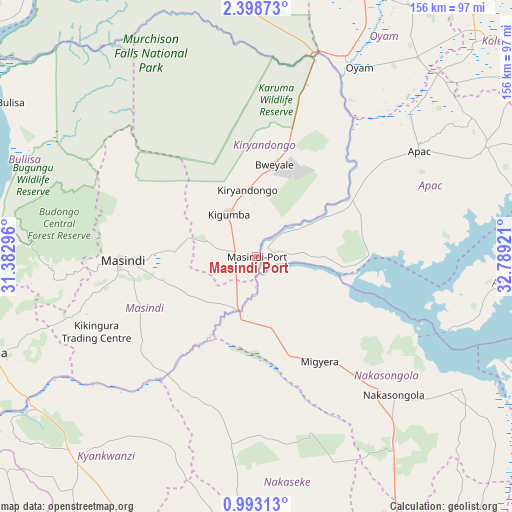
Masindi Port GPS coordinates[2]
1° 41' 45.816" North, 32° 5' 9.888" East
| Map corner | latitude | longitude |
|---|---|---|
| Upper-left | 2.39873°, | 31.38296° |
| Center: | 1.69606°, | 32.08608° |
| Lower-right: | 0.99313°, | 32.78921° |
| Map W x H: | 156.3×156.3 km | = 97.1×97.1mi |
| max Lat: | 3.66088° ⇑25.3% North |
| Masindi Port: | 1.69606° |
| min Lat: | ⇓74.7% South -1.28538° |
| min Long | Masindi Port | max Long |
| 29.65° | 32.08608° | 34.95° |
| W 44.5%⇐ | ⇒55.5% E |
Elevation
Elevation of Masindi Port is 1039 m = 3409 ft, and this is 220 m = 722 ft below average elevation for this country.
| Max E: |
4129 m = 13547 ft | 91.1% |
| Avg. | 1259 m = 4131 ft | |
| Masindi Port | 1039 m = 3409 ft | |
Min E: |
622 m = 2041 ft | 8.9% |
See also: Uganda elevation on elevation.city.
Geographical zone
Masindi Port is located in North Torrid zone (between Equator and Tropic of Cancer). Distance of Equator is 188.6 km =117.2 mi to South.| Distance of | km | miles | from Masindi Port |
|---|---|---|---|
| North Pole | 9818.5 | 6100.9 | to North |
| Arctic Circle | 7212.6 | 4481.7 | to North |
| Tropic Cancer | 2417.3 | 1502 | to North |
| Equator | 188.6 | 117.2 | to South |


Nearby cities:
15 places around Masindi Port: (largest is in red/bold)
• Amolatar
84.2 km =52.3 mi,  96°
96°
• Apac
59.1 km =36.7 mi,  58°
58°
• Bulisa
88.4 km =54.9 mi,  302°
302°
• Hoima
86.6 km =53.8 mi,  250°
250°
• Kiboga
93.4 km =58 mi,  201°
201°
• Kigorobya
86.8 km =53.9 mi,  264°
264°
• Kiryandongo
20.2 km =12.6 mi,  352°
352°
• Kyankwanzi
63.6 km =39.5 mi,  209°
209°
• Lira
109.4 km =68 mi, 55°
• Luwero
103.5 km =64.3 mi,  155°
155°
• Masindi
41.3 km =25.7 mi,  266°
266°
• Nakaseke
110.1 km =68.4 mi, 162°
• Nakasongola
59.6 km =37 mi,  136°
136°
• Nwoya
104.7 km =65.1 mi, 354°
• Oyam
68.5 km =42.6 mi,  28°
28°
Sources, notices
• [Note1] Compared only with cities in Uganda existing in our database
• [Src1] Map data: © OpenStreetMap contributors (CC-BY-SA)
• [Src2] Other city data from geonames.org with taken over terms of usage.
• [Src3] Geographical zone / Annual Mean Temperature by Robert A. Rohde @ Wikipedia
