Nebbi geodata
Nebbi (Northern Region) is a seat of a second-order administrative division; located in Uganda in Africa/Kampala (GMT+3) time zone. With population of 30,354 people, there are 27 cities with bigger population in this country. Compared to other cities in Uganda, 86.3% of cities are located further ↓South; 74% of cities are located further →East and 93.8% of cities have higher elevation than Nebbi. Note1
Administrative division(s):
- Level 1: Northern Region
- Level 2: Nebbi District
- Level 3: Padyere
- Level 4: Nebbi Town Council


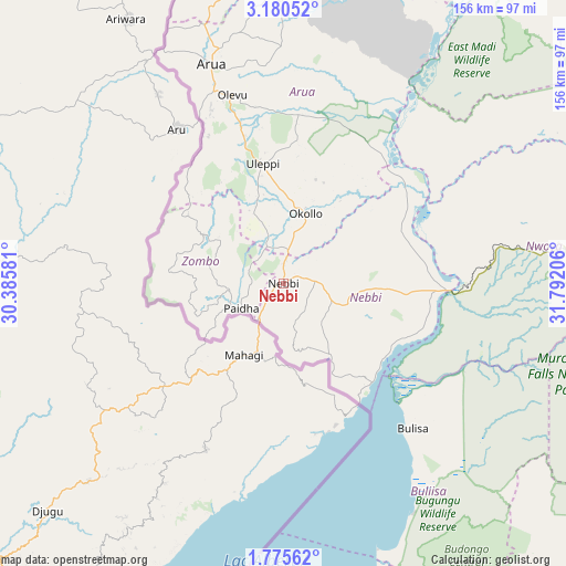
Nebbi GPS coordinates[2]
2° 28' 41.736" North, 31° 5' 20.148" East
| Map corner | latitude | longitude |
|---|---|---|
| Upper-left | 3.18052°, | 30.38581° |
| Center: | 2.47826°, | 31.08893° |
| Lower-right: | 1.77562°, | 31.79206° |
| Map W x H: | 156.2×156.2 km | = 97.1×97.1mi |
| max Lat: | 3.66088° ⇑13.7% North |
| Nebbi: | 2.47826° |
| min Lat: | ⇓86.3% South -1.28538° |
| min Long | Nebbi | max Long |
| 29.65° | 31.08893° | 34.95° |
| W 26%⇐ | ⇒74% E |
Elevation
Elevation of Nebbi is 1015 m = 3330 ft, and this is 244 m = 801 ft below average elevation for this country.
| Max E: |
4129 m = 13547 ft | 93.8% |
| Avg. | 1259 m = 4131 ft | |
| Nebbi | 1015 m = 3330 ft | |
Min E: |
622 m = 2041 ft | 6.2% |
See also: Uganda elevation on elevation.city.
Geographical zone
Nebbi is located in North Torrid zone (between Equator and Tropic of Cancer). Distance of Equator is 275.6 km =171.2 mi to South.| Distance of | km | miles | from Nebbi |
|---|---|---|---|
| North Pole | 9731.5 | 6046.9 | to North |
| Arctic Circle | 7125.6 | 4427.6 | to North |
| Tropic Cancer | 2330.4 | 1448 | to North |
| Equator | 275.6 | 171.2 | to South |


Nearby cities:
15 places around Nebbi: (largest is in red/bold)
• Adjumani
126.8 km =78.8 mi,  37°
37°
• Amuru
101.5 km =63.1 mi,  68°
68°
• Arua
63.4 km =39.4 mi,  341°
341°
• Bulisa
53.8 km =33.4 mi,  138°
138°
• Gulu
138.4 km =86 mi,  76°
76°
• Hoima
119.8 km =74.4 mi,  165°
165°
• Kigorobya
98.9 km =61.5 mi, 165°
• Kiryandongo
127.2 km =79 mi,  121°
121°
• Koboko
105 km =65.2 mi,  352°
352°
• Maracha
89.3 km =55.5 mi, 350°
• Masindi
113.3 km =70.4 mi, 142°
• Nwoya
102.8 km =63.9 mi, 80°
• Paidha
13.4 km =8.3 mi,  239°
239°
• Yumbe
111.1 km =69 mi,  9°
9°
• Zombo
20.4 km =12.7 mi,  281°
281°
Sources, notices
• [Note1] Compared only with cities in Uganda existing in our database
• [Src1] Map data: © OpenStreetMap contributors (CC-BY-SA)
• [Src2] Other city data from geonames.org with taken over terms of usage.
• [Src3] Geographical zone / Annual Mean Temperature by Robert A. Rohde @ Wikipedia
