Nwoya geodata
Nwoya (Northern Region) is a seat of a second-order administrative division; located in Uganda in Africa/Kampala (GMT+3) time zone. In our database, there are 80 cities with bigger population. Compared to other cities in Uganda, 89% of cities are located further ↓South; 57.5% of cities are located further →East and 93.2% of cities have higher elevation than Nwoya. Note1
Administrative division(s):
- Level 1: Northern Region
- Level 2: Nwoya District
- Level 3: Nwoya
- Level 4: Alero


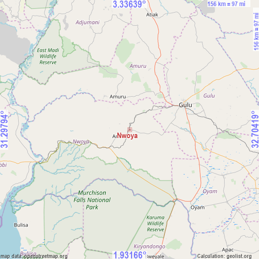
Nwoya GPS coordinates[2]
2° 38' 3.192" North, 32° 0' 3.816" East
| Map corner | latitude | longitude |
|---|---|---|
| Upper-left | 3.33639°, | 31.29794° |
| Center: | 2.63422°, | 32.00106° |
| Lower-right: | 1.93166°, | 32.70419° |
| Map W x H: | 156.2×156.2 km | = 97.1×97.1mi |
| max Lat: | 3.66088° ⇑11% North |
| Nwoya: | 2.63422° |
| min Lat: | ⇓89% South -1.28538° |
| min Long | Nwoya | max Long |
| 29.65° | 32.00106° | 34.95° |
| W 42.5%⇐ | ⇒57.5% E |
Elevation
Elevation of Nwoya is 1025 m = 3363 ft, and this is 234 m = 768 ft below average elevation for this country.
| Max E: |
4129 m = 13547 ft | 93.2% |
| Avg. | 1259 m = 4131 ft | |
| Nwoya | 1025 m = 3363 ft | |
Min E: |
622 m = 2041 ft | 6.8% |
See also: Uganda elevation on elevation.city.
Geographical zone
Nwoya is located in North Torrid zone (between Equator and Tropic of Cancer). Distance of Equator is 292.9 km =182 mi to South.| Distance of | km | miles | from Nwoya |
|---|---|---|---|
| North Pole | 9714.2 | 6036.1 | to North |
| Arctic Circle | 7108.3 | 4416.9 | to North |
| Tropic Cancer | 2313 | 1437.2 | to North |
| Equator | 292.9 | 182 | to South |


Nearby cities:
15 places around Nwoya: (largest is in red/bold)
• Adjumani
85.9 km =53.4 mi,  344°
344°
• Amuru
21.1 km =13.1 mi, 340°
• Apac
94.5 km =58.7 mi,  140°
140°
• Bulisa
87.1 km =54.1 mi,  228°
228°
• Gulu
36.6 km =22.7 mi,  64°
64°
• Kiryandongo
84.5 km =52.5 mi,  175°
175°
• Kitgum
121.7 km =75.6 mi,  53°
53°
• Kole
92.5 km =57.5 mi,  106°
106°
• Lira
108.6 km =67.5 mi, 113°
• Masindi
111.4 km =69.2 mi,  196°
196°
• Masindi Port
104.7 km =65.1 mi,  174°
174°
• Moyo
118.2 km =73.4 mi, 344°
• Nebbi
102.8 km =63.9 mi,  260°
260°
• Oyam
61.6 km =38.3 mi, 136°
• Paidha
115.4 km =71.7 mi, 257°
Sources, notices
• [Note1] Compared only with cities in Uganda existing in our database
• [Src1] Map data: © OpenStreetMap contributors (CC-BY-SA)
• [Src2] Other city data from geonames.org with taken over terms of usage.
• [Src3] Geographical zone / Annual Mean Temperature by Robert A. Rohde @ Wikipedia
