Gulu geodata
Gulu (Northern Region) is a seat of a first-order administrative division; located in Uganda in Africa/Kampala (GMT+3) time zone. With population of 146,858 people, there is 1 city with bigger population in this country. Compared to other cities in Uganda, 90.4% of cities are located further ↓South; 53.4% of cities are located further →East and 76% of cities have higher elevation than Gulu. Note1
Administrative division(s):
- Level 1: Northern Region
- Level 2: Gulu District
- Level 3: Gulu Municipality
- Level 4: Laroo


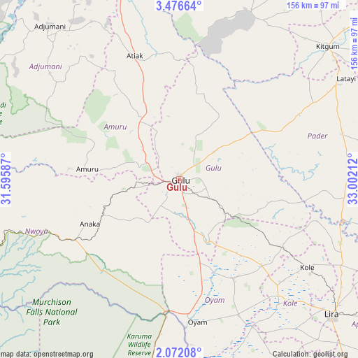
Gulu GPS coordinates[2]
2° 46' 28.452" North, 32° 17' 56.364" East
| Map corner | latitude | longitude |
|---|---|---|
| Upper-left | 3.47664°, | 31.59587° |
| Center: | 2.77457°, | 32.29899° |
| Lower-right: | 2.07208°, | 33.00212° |
| Map W x H: | 156.2×156.2 km | = 97.1×97.1mi |
| max Lat: | 3.66088° ⇑9.6% North |
| Gulu: | 2.77457° |
| min Lat: | ⇓90.4% South -1.28538° |
| min Long | Gulu | max Long |
| 29.65° | 32.29899° | 34.95° |
| W 46.6%⇐ | ⇒53.4% E |
Elevation
Elevation of Gulu is 1104 m = 3622 ft, and this is 155 m = 509 ft below average elevation for this country.
| Max E: |
4129 m = 13547 ft | 76% |
| Avg. | 1259 m = 4131 ft | |
| Gulu | 1104 m = 3622 ft | |
Min E: |
622 m = 2041 ft | 24% |
See also: Gulu elevation on elevation.city.
Geographical zone
Gulu is located in North Torrid zone (between Equator and Tropic of Cancer). Distance of Equator is 308.5 km =191.7 mi to South.| Distance of | km | miles | from Gulu |
|---|---|---|---|
| North Pole | 9698.6 | 6026.4 | to North |
| Arctic Circle | 7092.7 | 4407.2 | to North |
| Tropic Cancer | 2297.4 | 1427.5 | to North |
| Equator | 308.5 | 191.7 | to South |


Nearby cities:
15 places around Gulu: (largest is in red/bold)
• Adjumani
87.6 km =54.4 mi,  319°
319°
• Agago
115.1 km =71.5 mi,  86°
86°
• Alebtong
121.4 km =75.4 mi,  119°
119°
• Amuru
40.3 km =25 mi,  276°
276°
• Apac
92.7 km =57.6 mi,  163°
163°
• Kiryandongo
103.3 km =64.2 mi,  194°
194°
• Kitgum
86 km =53.4 mi,  49°
49°
• Kole
69.5 km =43.2 mi,  126°
126°
• Lamwo
100.8 km =62.6 mi,  33°
33°
• Lira
88.6 km =55.1 mi, 131°
• Moyo
117.4 km =72.9 mi,  327°
327°
• Nwoya
36.6 km =22.7 mi,  244°
244°
• Oyam
60.7 km =37.7 mi,  170°
170°
• Pader
106.4 km =66.1 mi,  73°
73°
• Pader Palwo
92.9 km =57.7 mi, 88°
Sources, notices
• [Note1] Compared only with cities in Uganda existing in our database
• [Src1] Map data: © OpenStreetMap contributors (CC-BY-SA)
• [Src2] Other city data from geonames.org with taken over terms of usage.
• [Src3] Geographical zone / Annual Mean Temperature by Robert A. Rohde @ Wikipedia
