Apac geodata
Apac (Northern Region) is a seat of a second-order administrative division; located in Uganda in Africa/Kampala (GMT+3) time zone. With population of 11,776 people, there are 55 cities with bigger population in this country. Compared to other cities in Uganda, 80.1% of cities are located further ↓South; 54.8% of cities are located further ←West and 89.7% of cities have higher elevation than Apac. Note1
Administrative division(s):
- Level 1: Northern Region
- Level 2: Apac District
- Level 3: Maruzi County
- Level 4: Apac Town Council


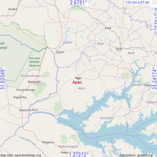
Apac GPS coordinates[2]
1° 58' 32.016" North, 32° 32' 18.996" East
| Map corner | latitude | longitude |
|---|---|---|
| Upper-left | 2.6781°, | 31.83549° |
| Center: | 1.97556°, | 32.53861° |
| Lower-right: | 1.27272°, | 33.24174° |
| Map W x H: | 156.3×156.3 km | = 97.1×97.1mi |
| max Lat: | 3.66088° ⇑19.9% North |
| Apac: | 1.97556° |
| min Lat: | ⇓80.1% South -1.28538° |
| min Long | Apac | max Long |
| 29.65° | 32.53861° | 34.95° |
| W 54.8%⇐ | ⇒45.2% E |
Elevation
Elevation of Apac is 1043 m = 3422 ft, and this is 216 m = 709 ft below average elevation for this country.
| Max E: |
4129 m = 13547 ft | 89.7% |
| Avg. | 1259 m = 4131 ft | |
| Apac | 1043 m = 3422 ft | |
Min E: |
622 m = 2041 ft | 10.3% |
See also: Uganda elevation on elevation.city.
Geographical zone
Apac is located in North Torrid zone (between Equator and Tropic of Cancer). Distance of Equator is 219.7 km =136.5 mi to South.| Distance of | km | miles | from Apac |
|---|---|---|---|
| North Pole | 9787.4 | 6081.6 | to North |
| Arctic Circle | 7181.5 | 4462.4 | to North |
| Tropic Cancer | 2386.3 | 1482.8 | to North |
| Equator | 219.7 | 136.5 | to South |


Nearby cities:
15 places around Apac: (largest is in red/bold)
• Alebtong
85 km =52.8 mi,  69°
69°
• Amolatar
52.2 km =32.4 mi,  140°
140°
• Buyende
114.4 km =71.1 mi, 143°
• Dokolo
71.5 km =44.4 mi,  96°
96°
• Gulu
92.7 km =57.6 mi,  343°
343°
• Kaberamaido
73.8 km =45.9 mi,  110°
110°
• Kiryandongo
54.1 km =33.6 mi,  258°
258°
• Kole
55.4 km =34.4 mi,  31°
31°
• Lira
50.4 km =31.3 mi,  52°
52°
• Masindi
97.5 km =60.6 mi,  249°
249°
• Masindi Port
59.1 km =36.7 mi,  238°
238°
• Nakasongola
74.7 km =46.4 mi,  187°
187°
• Nwoya
94.5 km =58.7 mi,  320°
320°
• Oyam
33.5 km =20.8 mi,  329°
329°
• Pader Palwo
113.2 km =70.3 mi,  35°
35°
Sources, notices
• [Note1] Compared only with cities in Uganda existing in our database
• [Src1] Map data: © OpenStreetMap contributors (CC-BY-SA)
• [Src2] Other city data from geonames.org with taken over terms of usage.
• [Src3] Geographical zone / Annual Mean Temperature by Robert A. Rohde @ Wikipedia
